
Tammy’s guidebook
Sightseeing
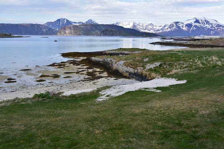
An easy scenic walk along the southern coast. There is also a beach area with tables and a heritage house.
Telegrafbukta bus stop right in front, take #33 there and #34 back. It's also not too much a walk to get there.
Note: It can get windy.
33 lokal ang nagrerekomenda
Tromso southern beach
An easy scenic walk along the southern coast. There is also a beach area with tables and a heritage house.
Telegrafbukta bus stop right in front, take #33 there and #34 back. It's also not too much a walk to get there.
Note: It can get windy.
It's a lovely town right on the Norwegian sea with especially pleasant beach & mountain vistas. The ride getting there is also wonderfully scenic.
There is a camping restaurant with outdoor seating.
Makes a great spot to see the lights though busses do not run late there.
Towards the end of the town there is a medium-difficulty rocky hike up to a good look out - it has a pretty steep solid rock part but there are large ropes to help keep your balance.
By bus, take the #42 to the last stop, then take bus #420 - be advised that the last bus only runs a few times a day.
42 lokal ang nagrerekomenda
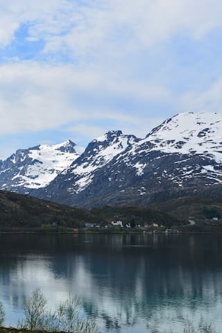
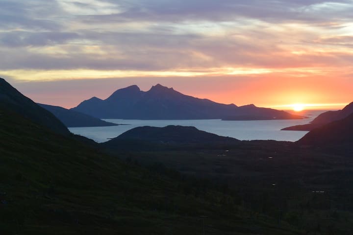
Sommarøy
It's a lovely town right on the Norwegian sea with especially pleasant beach & mountain vistas. The ride getting there is also wonderfully scenic.
There is a camping restaurant with outdoor seating.
Makes a great spot to see the lights though busses do not run late there.
Towards the end of the town there is a medium-difficulty rocky hike up to a good look out - it has a pretty steep solid rock part but there are large ropes to help keep your balance.
By bus, take the #42 to the last stop, then take bus #420 - be advised that the last bus only runs a few times a day.
A fjord town with a nice cafe/restaurant/craft store.
-River waterfalls (frozen in winter) are 5 mins from town walking.
-Nattmålsfjellet: A nice easy-level hike up a small mountain right next to town (towards Tromso island). About 45 mins up and down.
By bus, #42 to last stop, then #420 to 'Ersfordbotn' bus stop.
22 lokal ang nagrerekomenda
Ersfjordbotn
A fjord town with a nice cafe/restaurant/craft store.
-River waterfalls (frozen in winter) are 5 mins from town walking.
-Nattmålsfjellet: A nice easy-level hike up a small mountain right next to town (towards Tromso island). About 45 mins up and down.
By bus, #42 to last stop, then #420 to 'Ersfordbotn' bus stop.
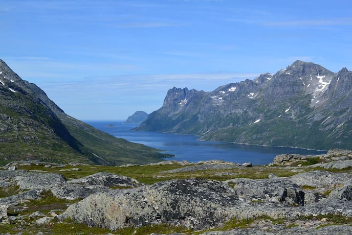
A medium difficulty (though not in winter) mountain hike with spectacular fjord views and overlooking Tromso island. Hike is about 3 hours up and down. There are some steep parts but nothing too bad (I climbed it). The trail goes through Ramnberger and Skåhammaren on the way.
By bus, take #42 to last stop, then #420 to "Ersfjordbotn Skole". #420 does not run frequently, please time your climb accordingly! The trail entrance is back up the road on your left at a small parking area.
Please ask and plan!
8 lokal ang nagrerekomenda
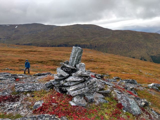
Buren
A medium difficulty (though not in winter) mountain hike with spectacular fjord views and overlooking Tromso island. Hike is about 3 hours up and down. There are some steep parts but nothing too bad (I climbed it). The trail goes through Ramnberger and Skåhammaren on the way.
By bus, take #42 to last stop, then #420 to "Ersfjordbotn Skole". #420 does not run frequently, please time your climb accordingly! The trail entrance is back up the road on your left at a small parking area.
Please ask and plan!
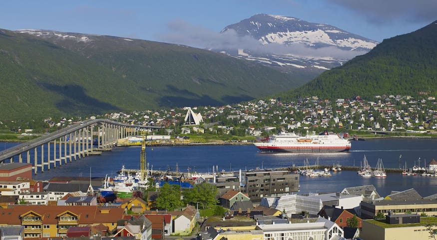
Additional to the Ishavskatedralen, Storsteinen/Fjellstua/Fjellhiesen and a few nice restuarants, Tromsdalen has some great and accessible hiking. There pleasant forest hiking (easy-level) in the valley along side the river. Good place for a picnic. The trail is suitable for children and biking and is nicely lit at night.
From there the trail starts for Nordfjellet, Scarsfjellet (on to Skarvassbu, Blåmannen & Rundfjellet), Fjellstua, Fløya, Bonntuva and even Tromsdalstinden.
9 lokal ang nagrerekomenda
Tromsdalen
Additional to the Ishavskatedralen, Storsteinen/Fjellstua/Fjellhiesen and a few nice restuarants, Tromsdalen has some great and accessible hiking. There pleasant forest hiking (easy-level) in the valley along side the river. Good place for a picnic. The trail is suitable for children and biking and is nicely lit at night.
From there the trail starts for Nordfjellet, Scarsfjellet (on to Skarvassbu, Blåmannen & Rundfjellet), Fjellstua, Fløya, Bonntuva and even Tromsdalstinden.
A super pleasant hike, across the valley from Fjellstua.
It is a really easy 45 minute hike to the base of the trail
(just outside Tromsdalen). The trail going up is medium-difficult (not in winter). Has some rocky terrain and a brief 45min steep part but through lovely forest next to a stream. Round trip about 3.5 hours.
The top is flatter rocky terrain with lush mosses. You can keep
going along the plateau towards Tromso to Nordfjellet/Blåmannen, keep going up to the big round Skarsvassbu, or go all the way to
Tromsdalstinden the steep way (if you now what you are doing).
Make it a loop by going along to top to the base of Tromsdalstinden and then down to the valley - adds about 1.5 hours to the trip.
Skarsfjellet
A super pleasant hike, across the valley from Fjellstua.
It is a really easy 45 minute hike to the base of the trail
(just outside Tromsdalen). The trail going up is medium-difficult (not in winter). Has some rocky terrain and a brief 45min steep part but through lovely forest next to a stream. Round trip about 3.5 hours.
The top is flatter rocky terrain with lush mosses. You can keep
going along the plateau towards Tromso to Nordfjellet/Blåmannen, keep going up to the big round Skarsvassbu, or go all the way to
Tromsdalstinden the steep way (if you now what you are doing).
Make it a loop by going along to top to the base of Tromsdalstinden and then down to the valley - adds about 1.5 hours to the trip.
A nice easy-level hike along the ridge of Tromso.
Start at Prestvannet lake and take the trail through the forest. Some nice look outs along the way, a few reindeer in the university pens, Rundvannnet lake and the winter Olympic ski jump.
About 2 hours roundtrip.
VardenToppen
A nice easy-level hike along the ridge of Tromso.
Start at Prestvannet lake and take the trail through the forest. Some nice look outs along the way, a few reindeer in the university pens, Rundvannnet lake and the winter Olympic ski jump.
About 2 hours roundtrip.
The most popular hike in the area, about a thousand
stairs to the top of Storstien cliff overlooking the island (and
Fjellstua cafe). About an hour up, easy-level, still a workout. Medium-to-hard-level in the winter depending on snow condition (good idea to have shoe spikes).
There is a gondala (Fjellheisen) to the top too! It's an added cost but also a cool experience.
For a little more hiking (30-45 mins), you can keep
going up to the peak of Fløya or beyond (trails go all the way to Tromsdalstinden).
It is also very nice to hike south, parallel with the cliff overlooking the island.
Storsteinen
The most popular hike in the area, about a thousand
stairs to the top of Storstien cliff overlooking the island (and
Fjellstua cafe). About an hour up, easy-level, still a workout. Medium-to-hard-level in the winter depending on snow condition (good idea to have shoe spikes).
There is a gondala (Fjellheisen) to the top too! It's an added cost but also a cool experience.
For a little more hiking (30-45 mins), you can keep
going up to the peak of Fløya or beyond (trails go all the way to Tromsdalstinden).
It is also very nice to hike south, parallel with the cliff overlooking the island.
A quiet nature area perpendicular to fjord overlooking the sea with several mountain trails. This spot is known for northern lights watching because it has very low light pollution.
Trails start to the south and the north and can't be missed. The south trails are easy-level and slowly wind up moutains. The north trail is more medium-level (not in winter) with steeper rocky parts but has better views of the sea.
Finnvikvatnet
A quiet nature area perpendicular to fjord overlooking the sea with several mountain trails. This spot is known for northern lights watching because it has very low light pollution.
Trails start to the south and the north and can't be missed. The south trails are easy-level and slowly wind up moutains. The north trail is more medium-level (not in winter) with steeper rocky parts but has better views of the sea.
The iconic mountain of Tromsø!
The views are awe-inspiring-amazing, in all directions. It is quite worth climbing. Also known as 'Tinden' or 'Sálašoaivi' in Sami.
For most of us, this is high-level difficulty climb, very steep (depending on which side you climb) with trails on cliff edges, loose rocks, easily 10c colder and sometimes extreme wind (wind that can knock you down, or over).
There are severals trails you can take up:
Main trails start at the end of Tromsdalen valley (about a 2 hour walk), you can pick the right-hand south slope (by Rødryogan, +4 hours to peak) or the left-hand north steep slope (+2 hours to peak)
My partner's favorite is through Skarsfjellet then up the steep but less lengthy side.
Please ask and plan!
Not for winter hiking unless you go with an expert - avalanches, very cold windchill, ice and floating snow (snow that only has snow under it and no actual mountain).
23 lokal ang nagrerekomenda

Tromsdalstinden
The iconic mountain of Tromsø!
The views are awe-inspiring-amazing, in all directions. It is quite worth climbing. Also known as 'Tinden' or 'Sálašoaivi' in Sami.
For most of us, this is high-level difficulty climb, very steep (depending on which side you climb) with trails on cliff edges, loose rocks, easily 10c colder and sometimes extreme wind (wind that can knock you down, or over).
There are severals trails you can take up:
Main trails start at the end of Tromsdalen valley (about a 2 hour walk), you can pick the right-hand south slope (by Rødryogan, +4 hours to peak) or the left-hand north steep slope (+2 hours to peak)
My partner's favorite is through Skarsfjellet then up the steep but less lengthy side.
Please ask and plan!
Not for winter hiking unless you go with an expert - avalanches, very cold windchill, ice and floating snow (snow that only has snow under it and no actual mountain).
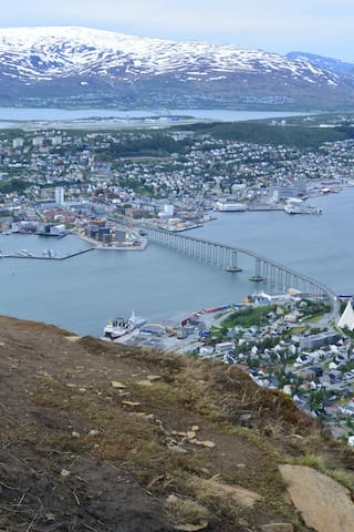
A nice little lookout area over downtown that is about a 10 minute walk uphill from the apartment.
Nice sunset and city auroras point if you happen to be walking nearby.
Tromsö Viewpoint
18 DramsvegenA nice little lookout area over downtown that is about a 10 minute walk uphill from the apartment.
Nice sunset and city auroras point if you happen to be walking nearby.
Payo sa lungsod
Paano makapaglibot
Getting around by bus
Paying by cash is more money, so either buy a ticket from a machine (One at airport stop, but not at every stop), get a reloadable card at a convenience store or download the app.
Search for 'Fylkestrafikk' to find the website.
Note: Your usual phone Map apps will be good but not 100%.
You can also take them outside the city but they don't run very frequently, less on weekends. These busses have three digit numbers, like #420.
You can definitely walk all over but some days are cold and rainy. During the winter, ice can be pretty bad and shoe spikes are highly recommended even in downtown!
Bago ka umalis
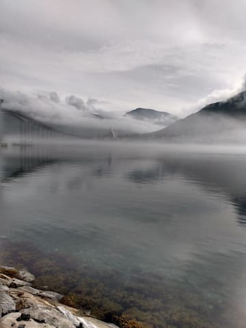
Seeing Northern Lights in Autumn/Winter
Norther Lights can be seen from the roof with clear skies, better on a mountain, best experience & photos with tours.
Please set your expectations. Sometimes clouds just get in the way. A good idea to plan multiple tour days. Best time of year is around the equinoxes. For lower KP level storms it will be less intense, watch patiently to let the dance unfold!
* If the weather is not great during your stay, tours will greatly increase your chance of seeing them! *
Search "Tromso YR weather" for the local weather site, then, click the "Nearby" tab & scroll down to see the Aurora section.
Huwag palampasin
Hiking and Climbing
Tromsø has trails for every level of adventurer. Listed are some easy & medium level non-winter hikes accessible by bus routes.
For more advanced or winter hikes, try an advenure tour! You'll get to places you can't get to by bus and stay safer on tricker trails, plus they'll have gear.
In the winter there are avalanches, dangerous ice and hiden cliffs plus rapidly changing weather.
These are suggestions based on personal experience from my recent time living here, please ask about details and plan! Website for trails, search "UT . NO"
Ang dapat iempake
New to winter? What to wear...
Layering is good for warmth & flexibility as weather can change quickly. Carry a backpack to add/remove layers as needed.
1) Inner layer that isn't cotton, I use synthetic sport shirts & thicker looser yoga pants. Extra cold days I add a non-cotton cardigan. Wool socks <B
2) For middle layer wool sweaters are best. I usually have one thick one & one thinner one so I can stack & adapt as needed.
3) Outside layer, rain/wind-proof jacket (or light to medium coat) with adjustable tightness that fits over the sweaters. Regular loose pants unless you are skiing. Warm hat, scarf & gloves/mitts!
Bago ka umalis
Polar Night Tips
There is a slight sky glow for a few hours during the day. Our apartment has lights on a schedule (7:30 - 21:30) to help regulate your internal clock.
Tromso is well lit & can be quite charming with all the lights. Still a good idea to carry a small flashlight (saves phone battery) & light reflectors for walking.
The darkness can make it harder to wake up with full energy. Phone alarm apps that can mimic sunrise help (try "Wakening" app).
Take Vitamin D spray, or eat local whale meat, for longer stays.
Most of all stay active! Cafes provide bright warm boosts along the way.