
Orchard House Guidebook
Favorite Family Hiking Trails Nearby
When you want to take your family hiking for some fun outdoors, it's always good to know safe, family friendly places to go.
"Big Acorn Trail" This family hiking trail starts at the Carters Lake Visitor Center which also serves as a nature center. They have plenty of educational, fun, and free things for kids at the Visitor Center. The hike is 2/3 mile round trip to the lake view overlook and back. This trail is short, easy and great for small children who just want to be trail leaders.
"Tumbling Waters Nature Trail" If the Big Acorn Trail isn't long enough for you this trail is on the other side of the lake (at least a 30 minute drive around the lake from Carters Lake Visitor Center) in the Ridgeway Recreation Area. The total walking distance of this trail is slightly over one mile, but has many scenic stops along the way. It includes a 150-foot long bridge that crosses 30 feet over Tails Creek and ends at the cascade’s peak, but don't miss the other part of trail that leads to an overlook featuring a view of the gentle cascade. Good To Know: A $5.00 per vehicle use fee is charged at most day use areas at Carters Lake. Fees can be paid at self deposit fee vaults or at staffed entrance stations. Visitors may also purchase an Annual Pass that allows vehicles to gain access at no cost to all U.S Army Corps of Engineers day use areas.
50 lokal ang nagrerekomenda
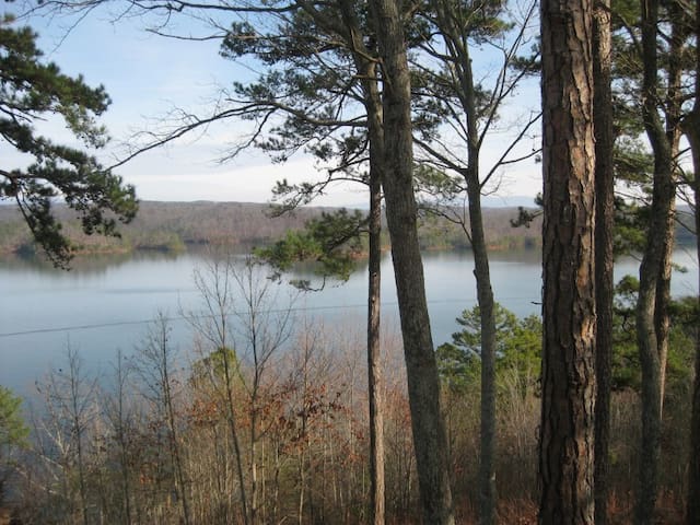
Carters Lake
"Big Acorn Trail" This family hiking trail starts at the Carters Lake Visitor Center which also serves as a nature center. They have plenty of educational, fun, and free things for kids at the Visitor Center. The hike is 2/3 mile round trip to the lake view overlook and back. This trail is short, easy and great for small children who just want to be trail leaders.
"Tumbling Waters Nature Trail" If the Big Acorn Trail isn't long enough for you this trail is on the other side of the lake (at least a 30 minute drive around the lake from Carters Lake Visitor Center) in the Ridgeway Recreation Area. The total walking distance of this trail is slightly over one mile, but has many scenic stops along the way. It includes a 150-foot long bridge that crosses 30 feet over Tails Creek and ends at the cascade’s peak, but don't miss the other part of trail that leads to an overlook featuring a view of the gentle cascade. Good To Know: A $5.00 per vehicle use fee is charged at most day use areas at Carters Lake. Fees can be paid at self deposit fee vaults or at staffed entrance stations. Visitors may also purchase an Annual Pass that allows vehicles to gain access at no cost to all U.S Army Corps of Engineers day use areas.
"The Old Fort Trail" The Old Fort Trail is 1.6 miles and leads to the rock wall, stone tower and overlooks. Kids love the tower and you can tell them the story of the heart shaped stone. The many scenic overlooks make for great photo ops for the family. Fort Mountain State Park offers many picnic areas and activities for the family. You can enjoy a lunch by the lake then hike our next trail.
"The Lake Loop Trail" This trail is a 1.2 mile hike around the lake, tell the kids you are going on a bear hunt as you hike through the lush woods around the lake. You can bring your fishing pole and stop at many areas to fish around the lake. Good To Know: A $5.00 per vehicle use fee is charged at Georgia State Parks. Visitors can also purchase an Annual Pass that allows vehicles to gain access at no cost to all Georgia State Parks. Georgia law requires that anyone 16 and older have a fishing license in their possession. You can purchase one online from the Electronic Georgia Licensing (EGAL) system. Rest assured, by purchasing a license, you’re supporting the fisheries management and conservation of Georgia’s aquatic resources.
64 lokal ang nagrerekomenda
Fort Mountain State Park
181 Fort Mountain State Park Rd"The Old Fort Trail" The Old Fort Trail is 1.6 miles and leads to the rock wall, stone tower and overlooks. Kids love the tower and you can tell them the story of the heart shaped stone. The many scenic overlooks make for great photo ops for the family. Fort Mountain State Park offers many picnic areas and activities for the family. You can enjoy a lunch by the lake then hike our next trail.
"The Lake Loop Trail" This trail is a 1.2 mile hike around the lake, tell the kids you are going on a bear hunt as you hike through the lush woods around the lake. You can bring your fishing pole and stop at many areas to fish around the lake. Good To Know: A $5.00 per vehicle use fee is charged at Georgia State Parks. Visitors can also purchase an Annual Pass that allows vehicles to gain access at no cost to all Georgia State Parks. Georgia law requires that anyone 16 and older have a fishing license in their possession. You can purchase one online from the Electronic Georgia Licensing (EGAL) system. Rest assured, by purchasing a license, you’re supporting the fisheries management and conservation of Georgia’s aquatic resources.
"Base of the Falls Trail" At 729 feet, Amicalola Falls is the tallest cascading waterfall in the Southeast, and that's why we think the Base of the Falls Trail is a top hiking trail for the family. This family hiking trail is considered moderate to strenuous due to the steep slope and stairs (604 Stairs to be exact), but there are plenty of benches and you will want to stop and take lots of photos on your way up. It is one mile from the base of the falls to the overlook at the top of the falls. There are also plenty of playgrounds and picnic areas for the family to enjoy. Good To Know: Like Fort Mountain State Park, there is a $5.00 per vehicle use fee.
"Bear Creek Trail" The Bear Creek Trail is located in the Chattahoochee National Forest, and provides some of the most beautiful woods and trees around, including the Gennett Poplar, the state record Tulip Poplar, the second tallest tree in Georgia. This family hiking trail overs a variety of options in length but if you are simply wanting to hike to the tree and back, it is 1.8 miles. Good To Know: There are creek crossings, so you may want to bring extra shoes just in case the little ones play in the creek. GPS doesn't always work in the National Forrest so here are some directions to help:From the Ellijay town square follow GA Hwy 52 West for 5 miles and turn right onto Gates Chapel Road. Look for milepost 8 and signs for Bear Creek and Lake Conasauga Follow Gates Chapel Road 5 miles to FS Road # 241 (this is a gravel road). You make take FS #241 up to the lower trailhead or park on the side of Gates Chapel Road just past FS #241. If you do park on the side of Gates Chapel Road please be considerate of our neighbors that live on this road.
"The River Loop on the Cartecay River" The longest of all our recommended hikes, at 3.5 miles, this family hiking trail offers views of the beautiful mountains, the Cartecay River and Clear Creek Falls. This hike might not be best for small children as there are some step declines near the Cartecay River. Good to Know: Start this trail early if you are bringing the family to allow time to catch your breath and take in the views. This is also a Wildlife Management Area and you will need to purchase a WMA license or a Georgia Outdoor Recreational Pass, which ranges from $3.50 for a 3-day pass to $20.00 for a year. Again, GPS may not work so here are some directions to help: From Ellijay follow GA Highway 52 East for approximately 3.0 miles to Mulkey Road (County Road 225) on the right. Follow Mulkey Road approximately 0.4 miles and turn right onto paved road at Rich Mountain Cartecay Tract sign. At mile 0.15 in a sharp curve turn right at another Rich Mountain Cartecay Tract sign. Follow this dirt road for 0.15 miles to the parking area just before the gate.
"Trout Adventure Trail" The Trout Adventure Trail is a "do it yourself" and "plan your own" family hiking and learning experience for kids of all ages along legendary trails in the Chattahoochee National Forest in north Georgia. It offers individual hikers, families and organized groups the opportunity to hike, learn and earn a free decorative commemorative patch as recognition of the commitment to outdoor education, conservation and accomplishment. There are many routes that you can take, but we recommend the Blue Trail which is Three Forks to Long Creek Falls and back. An easy 2.2 miles will take you on a hike to the beautiful Long Creek Falls. For more information on earning the patch and learning opportunities visit the Trout Adventure Trail website. Good To Know: Again, GPS doesn't always work so here are some directions to help: Take Highway 52 east of Ellijay, turn LEFT onto Hwy 52 and travel 5.3 miles to Big Creek Road. Turn Left on Big Creek Road and travel 8.5 miles straight onto Doublehead Gap Road. Continue heading southeast and then northeast on Doublehead Gap Road approx. 6.4 miles to intersection with FS Road 58. (Paved road becomes gravel road for last .3 miles and FS Road 58 is on right just past church on left). Turn Right on FS Road 58 (gravel road) also called Noontootla Road. Proceed 5.3 miles on FS 58 past farm, past curve and gradual climb to Three Forks. We hope these trails will help you and your family visit Ellijay and enjoy our beautiful outdoors.
261 lokal ang nagrerekomenda
Amicalola Falls State Park
418 Amicalola Falls State Park Rd"Base of the Falls Trail" At 729 feet, Amicalola Falls is the tallest cascading waterfall in the Southeast, and that's why we think the Base of the Falls Trail is a top hiking trail for the family. This family hiking trail is considered moderate to strenuous due to the steep slope and stairs (604 Stairs to be exact), but there are plenty of benches and you will want to stop and take lots of photos on your way up. It is one mile from the base of the falls to the overlook at the top of the falls. There are also plenty of playgrounds and picnic areas for the family to enjoy. Good To Know: Like Fort Mountain State Park, there is a $5.00 per vehicle use fee.
"Bear Creek Trail" The Bear Creek Trail is located in the Chattahoochee National Forest, and provides some of the most beautiful woods and trees around, including the Gennett Poplar, the state record Tulip Poplar, the second tallest tree in Georgia. This family hiking trail overs a variety of options in length but if you are simply wanting to hike to the tree and back, it is 1.8 miles. Good To Know: There are creek crossings, so you may want to bring extra shoes just in case the little ones play in the creek. GPS doesn't always work in the National Forrest so here are some directions to help:From the Ellijay town square follow GA Hwy 52 West for 5 miles and turn right onto Gates Chapel Road. Look for milepost 8 and signs for Bear Creek and Lake Conasauga Follow Gates Chapel Road 5 miles to FS Road # 241 (this is a gravel road). You make take FS #241 up to the lower trailhead or park on the side of Gates Chapel Road just past FS #241. If you do park on the side of Gates Chapel Road please be considerate of our neighbors that live on this road.
"The River Loop on the Cartecay River" The longest of all our recommended hikes, at 3.5 miles, this family hiking trail offers views of the beautiful mountains, the Cartecay River and Clear Creek Falls. This hike might not be best for small children as there are some step declines near the Cartecay River. Good to Know: Start this trail early if you are bringing the family to allow time to catch your breath and take in the views. This is also a Wildlife Management Area and you will need to purchase a WMA license or a Georgia Outdoor Recreational Pass, which ranges from $3.50 for a 3-day pass to $20.00 for a year. Again, GPS may not work so here are some directions to help: From Ellijay follow GA Highway 52 East for approximately 3.0 miles to Mulkey Road (County Road 225) on the right. Follow Mulkey Road approximately 0.4 miles and turn right onto paved road at Rich Mountain Cartecay Tract sign. At mile 0.15 in a sharp curve turn right at another Rich Mountain Cartecay Tract sign. Follow this dirt road for 0.15 miles to the parking area just before the gate.
"Trout Adventure Trail" The Trout Adventure Trail is a "do it yourself" and "plan your own" family hiking and learning experience for kids of all ages along legendary trails in the Chattahoochee National Forest in north Georgia. It offers individual hikers, families and organized groups the opportunity to hike, learn and earn a free decorative commemorative patch as recognition of the commitment to outdoor education, conservation and accomplishment. There are many routes that you can take, but we recommend the Blue Trail which is Three Forks to Long Creek Falls and back. An easy 2.2 miles will take you on a hike to the beautiful Long Creek Falls. For more information on earning the patch and learning opportunities visit the Trout Adventure Trail website. Good To Know: Again, GPS doesn't always work so here are some directions to help: Take Highway 52 east of Ellijay, turn LEFT onto Hwy 52 and travel 5.3 miles to Big Creek Road. Turn Left on Big Creek Road and travel 8.5 miles straight onto Doublehead Gap Road. Continue heading southeast and then northeast on Doublehead Gap Road approx. 6.4 miles to intersection with FS Road 58. (Paved road becomes gravel road for last .3 miles and FS Road 58 is on right just past church on left). Turn Right on FS Road 58 (gravel road) also called Noontootla Road. Proceed 5.3 miles on FS 58 past farm, past curve and gradual climb to Three Forks. We hope these trails will help you and your family visit Ellijay and enjoy our beautiful outdoors.
Sightseeing
This is a wonderful park with well-maintained walking trails which meander along the river. On the opposite side of the path are baseball fields, swimming pool, tennis courts, riding arena and the fields used for the Apple Festival. There are benches and rest areas along the path as well as exercise stations. I walked it with my dog after several days of rain without a problem. Great break for visitors and used by the community as well!
9 lokal ang nagrerekomenda
Vets Memorial Park- Ellijay
2150 Old Hwy 5This is a wonderful park with well-maintained walking trails which meander along the river. On the opposite side of the path are baseball fields, swimming pool, tennis courts, riding arena and the fields used for the Apple Festival. There are benches and rest areas along the path as well as exercise stations. I walked it with my dog after several days of rain without a problem. Great break for visitors and used by the community as well!
Beautiful park. Lots of walking, biking dog walking. There is hike in camping if you're interested.
14 lokal ang nagrerekomenda
Amadahy
3633 Woodring Branch RdBeautiful park. Lots of walking, biking dog walking. There is hike in camping if you're interested.
Town Creek Valley Farm is a family owned farm in Talking Rock, GA that offers a four acre corn maze, u-pick flowers, and more during the weekends.

Town Creek Valley Farm
7310 Old Highway 5 SouthTown Creek Valley Farm is a family owned farm in Talking Rock, GA that offers a four acre corn maze, u-pick flowers, and more during the weekends.
Shopping
Stop by Old Orchard Square to stock your pantry at Ingles, dine at Okinawa Hibachi & Sushi or Pizza King, get a mani/pedi at Lucky Nails, focus on wellness at Benchmark Physical Therapy or shop for your home at Black Bear Antiques or Farmers Home Furniture. Conveniently located on SR-515 in East Ellijay.

Old Orchard Square
Old Orchard SquareStop by Old Orchard Square to stock your pantry at Ingles, dine at Okinawa Hibachi & Sushi or Pizza King, get a mani/pedi at Lucky Nails, focus on wellness at Benchmark Physical Therapy or shop for your home at Black Bear Antiques or Farmers Home Furniture. Conveniently located on SR-515 in East Ellijay.