
White River Adventure Cabin Guidebook
Food Scene
Combs Store and Cafe is just a mile and about 4 miles from the cabin and is open until 6:3o Sunday-Thursday and until 8:oo Friday-Saturday. 10342 AR-16, Combs, AR 72721
The Combs Store & Cafe
10342 AR-16Combs Store and Cafe is just a mile and about 4 miles from the cabin and is open until 6:3o Sunday-Thursday and until 8:oo Friday-Saturday. 10342 AR-16, Combs, AR 72721
Dollar General is just a mile down the road and stays open until 9:oo! 5096 Hwy. 23 St. Paul, AR
Dollar General
5096 AR-23Dollar General is just a mile down the road and stays open until 9:oo! 5096 Hwy. 23 St. Paul, AR
Good food, Great views!
https://www.yelp.com/biz/byrds-riverfront-restaurant-ozark

Byrd's Mulberry Riverfront Restaurant
7037 Cass Oark RoadGood food, Great views!
https://www.yelp.com/biz/byrds-riverfront-restaurant-ozark
The Oark General Store, listed in the Arkansas Register of Historic Places, was opened in 1890 in response to demand for groceries and supplies in the isolated community of Oark, in northern Johnson County. The Store has served the area ever since, giving it the distinct recognition of being the oldest continually-operated store in the Natural State.
The rural community of Oark is surrounded by the Ozark National Forest and has access to many natural settings: The Mulberry River, a National Wild and Scenic River; the Ozark Highlands Trail, a spectacular 200-mile trail great for day hikes and camping; and countless miles of off-road trails for outdoor enthusiasts, including the legendary Trans-America Trail.
In recent years, the Oark General Store has become an attractive destination for both on and off-road travelers due to its location along windy and dramatic Ozark highways. The Store has transitioned from mainly groceries and supplies to a full-service restaurant, serving fresh quality ingredients with a smile.
Its a one-of-a-kind drive-to-eat experience everyone must try.
http://www.oarkgeneralstore.com/
24 lokal ang nagrerekomenda
Oark General Store
117 Co Rd 5241The Oark General Store, listed in the Arkansas Register of Historic Places, was opened in 1890 in response to demand for groceries and supplies in the isolated community of Oark, in northern Johnson County. The Store has served the area ever since, giving it the distinct recognition of being the oldest continually-operated store in the Natural State.
The rural community of Oark is surrounded by the Ozark National Forest and has access to many natural settings: The Mulberry River, a National Wild and Scenic River; the Ozark Highlands Trail, a spectacular 200-mile trail great for day hikes and camping; and countless miles of off-road trails for outdoor enthusiasts, including the legendary Trans-America Trail.
In recent years, the Oark General Store has become an attractive destination for both on and off-road travelers due to its location along windy and dramatic Ozark highways. The Store has transitioned from mainly groceries and supplies to a full-service restaurant, serving fresh quality ingredients with a smile.
Its a one-of-a-kind drive-to-eat experience everyone must try.
http://www.oarkgeneralstore.com/

Turner Bend Outfitters
20034 AR-23Food & Clothing
https://turnerbend.com/Store.html
Carry out only. Small venue with no seating
https://www.facebook.com/Saints-Snack-Shack-159200090891717/

Saints Snack Shack
480 Madison AvenueCarry out only. Small venue with no seating
https://www.facebook.com/Saints-Snack-Shack-159200090891717/
Sightseeing/Hiking
Wonderful hiking and sightseeing close by! Visit AllTrails.com for detailed info on local hiking. https://www.alltrails.com/us/arkansas/saint-paul
Redding/Spy Rock Loop Trailhead
Wonderful hiking and sightseeing close by! Visit AllTrails.com for detailed info on local hiking. https://www.alltrails.com/us/arkansas/saint-paul
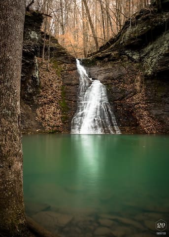
Unbelievable views from one of the most visited sights in Arkansas! https://www.alltrails.com/explore/trail/us/arkansas/whitaker-point-trail-hawksbill-crag
59 lokal ang nagrerekomenda
Hawk's Bill Crag/Whitaker Point
County Road 406Unbelievable views from one of the most visited sights in Arkansas! https://www.alltrails.com/explore/trail/us/arkansas/whitaker-point-trail-hawksbill-crag
Murray & Senyard Falls Trail
https://www.alltrails.com/explore/trail/us/arkansas/murray-senyard-falls-hike

Cherry Bend Recreation Area
Murray & Senyard Falls Trail
https://www.alltrails.com/explore/trail/us/arkansas/murray-senyard-falls-hike
Lots of trails in the area!
https://www.alltrails.com/explore/trail/us/arkansas/paradise-falls--2?ref=result-card
Paradise Falls
Lots of trails in the area!
https://www.alltrails.com/explore/trail/us/arkansas/paradise-falls--2?ref=result-card
Just 40 mins east, experience this 1.90 mile, out and back trail near Deer, Arkansas. Generally considered a moderately challenging route, it takes an average of 1 h 3 min to complete. This is a very popular area for hiking and other nature trips, so you'll likely encounter other people while exploring. The trail is open year-round and is beautiful to visit anytime. Dogs are welcome, but must be on a leash.
https://www.alltrails.com/trail/us/arkansas/glory-hole-waterfall-trail
49 lokal ang nagrerekomenda
Glory Hole Falls Trailhead
Glory Hole Falls TrailJust 40 mins east, experience this 1.90 mile, out and back trail near Deer, Arkansas. Generally considered a moderately challenging route, it takes an average of 1 h 3 min to complete. This is a very popular area for hiking and other nature trips, so you'll likely encounter other people while exploring. The trail is open year-round and is beautiful to visit anytime. Dogs are welcome, but must be on a leash.
https://www.alltrails.com/trail/us/arkansas/glory-hole-waterfall-trail
The main section of the Upper Buffalo Wilderness was designated in 1974 with additional acreages created by the 1984 Arkansas Wilderness Act totaling approximately 12.000 acres. This is one of the 3 wildernesses on the Buffalo Ranger District. The forest cover is mostly second and third growth oak-hickory. Some scattered stands of shortleaf pine in old fields still exist from when the Forest Service purchased the land in the 1930s and 1940s. The route to Hawksbill Crag is the only designated hiking trail located in the wilderness. The trail is developed but unmarked. A system of old lodging roads that runs throughout the area provides and informal network of trails for hiking and horseback rising. There are four developed access points to reach the Upper Buffalo Wilderness : Hawksbill Crag, Kapark Cemetery, Dahl Memorial, and Boen Gulf. Point of interest- Hawksbill Crag Rock Formation.
Upper Buffalo Wilderness
The main section of the Upper Buffalo Wilderness was designated in 1974 with additional acreages created by the 1984 Arkansas Wilderness Act totaling approximately 12.000 acres. This is one of the 3 wildernesses on the Buffalo Ranger District. The forest cover is mostly second and third growth oak-hickory. Some scattered stands of shortleaf pine in old fields still exist from when the Forest Service purchased the land in the 1930s and 1940s. The route to Hawksbill Crag is the only designated hiking trail located in the wilderness. The trail is developed but unmarked. A system of old lodging roads that runs throughout the area provides and informal network of trails for hiking and horseback rising. There are four developed access points to reach the Upper Buffalo Wilderness : Hawksbill Crag, Kapark Cemetery, Dahl Memorial, and Boen Gulf. Point of interest- Hawksbill Crag Rock Formation.
This bushwhack was into Hanging Rock Hollow, near Mulberry Mountain. We dropped into Wellcave Hollow and worked our way along Mountain Creek and then turned right into Hanging Rock Hollow. Once past the confluence, we left the drainage and worked our way up to Hanging Rock on Fly Gap road. Afterwards, we dropped into the west side drainage and worked our way back to the confluence and then eventually back to Mountain Creek. Very strenuous hike with 1950 ft. of elevation gain. Search youtube video
Hanging Rock Hollow Falls
This bushwhack was into Hanging Rock Hollow, near Mulberry Mountain. We dropped into Wellcave Hollow and worked our way along Mountain Creek and then turned right into Hanging Rock Hollow. Once past the confluence, we left the drainage and worked our way up to Hanging Rock on Fly Gap road. Afterwards, we dropped into the west side drainage and worked our way back to the confluence and then eventually back to Mountain Creek. Very strenuous hike with 1950 ft. of elevation gain. Search youtube video
White Rock Mountain Creek Falls Trail
Head out on this 5.8-mile out-and-back trail near Ozark, Arkansas. Generally considered a moderately challenging route, it takes an average of 2 h 24 min to complete. This trail is great for hiking, and it's unlikely you'll encounter many other people while exploring. The trail is open year-round and is beautiful to visit anytime. Dogs are welcome, but must be on a leash. The trail descends steadily for about 2 miles until you get to White Rock Creek, crossing Forest Road 1003 on the way (this is probably the road you drove up to get to White Rock). The area around the creek has many features. First, the trail will cross the creek twice in 0.2 miles and your crossings can be wet if the water is up. Second, there are lots of flat areas for camping just as you reach the first crossing and on the other side. There is a grotto up the creek before the first crossing that has a high but small waterfall (probably dry in the summer). Last, but not least, is the water fall between the two crossings. It is high volume with a large pool and can be seen from either side of the creek.
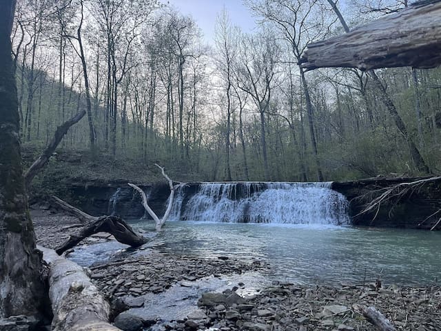
White Rock Mountain, Arkansas 72959, Estados Unidos
White Rock Mountain Creek Falls Trail
Head out on this 5.8-mile out-and-back trail near Ozark, Arkansas. Generally considered a moderately challenging route, it takes an average of 2 h 24 min to complete. This trail is great for hiking, and it's unlikely you'll encounter many other people while exploring. The trail is open year-round and is beautiful to visit anytime. Dogs are welcome, but must be on a leash. The trail descends steadily for about 2 miles until you get to White Rock Creek, crossing Forest Road 1003 on the way (this is probably the road you drove up to get to White Rock). The area around the creek has many features. First, the trail will cross the creek twice in 0.2 miles and your crossings can be wet if the water is up. Second, there are lots of flat areas for camping just as you reach the first crossing and on the other side. There is a grotto up the creek before the first crossing that has a high but small waterfall (probably dry in the summer). Last, but not least, is the water fall between the two crossings. It is high volume with a large pool and can be seen from either side of the creek.
The Rim Trail on White Rock Mountain in the Ozark National Forest about 20 miles north of Mulberry is an awesome trail, and it is not difficult. It is a 1.9-mile loop with less than 100 feet net elevation change. The Rim Trail is over 2200 feet above sea level, and almost the entire trail has amazing vista views of the surrounding Ozark mountains.
Getting to White Rock Mountain
To get to White Rock Mountain from the south, take Exit 24 from I-40. At Exit 24, get on Arkansas Highway 215 heading north. It is about 22 miles from Exit 24 to the White Rock Mountain Recreation Area. Once you are in the national forest, just follow the signs. You will be passing Shores Lake on the right on your way to the mountain. Be prepared for gravel roads on the way there.
For specific directions from different areas, I would suggest giving them a call.
12 lokal ang nagrerekomenda
White Rock Mountain
214 Bowles Gap RdThe Rim Trail on White Rock Mountain in the Ozark National Forest about 20 miles north of Mulberry is an awesome trail, and it is not difficult. It is a 1.9-mile loop with less than 100 feet net elevation change. The Rim Trail is over 2200 feet above sea level, and almost the entire trail has amazing vista views of the surrounding Ozark mountains.
Getting to White Rock Mountain
To get to White Rock Mountain from the south, take Exit 24 from I-40. At Exit 24, get on Arkansas Highway 215 heading north. It is about 22 miles from Exit 24 to the White Rock Mountain Recreation Area. Once you are in the national forest, just follow the signs. You will be passing Shores Lake on the right on your way to the mountain. Be prepared for gravel roads on the way there.
For specific directions from different areas, I would suggest giving them a call.
Further Away
Just about an hour away there is a great art museum. Beautiful inside and out. Beautiful walking trails around the museum.
708 lokal ang nagrerekomenda
Crystal Bridges Museum of American Art
600 Museum WayJust about an hour away there is a great art museum. Beautiful inside and out. Beautiful walking trails around the museum.
The Big Buffalo Valley Historic District, also known as the Boxley Valley Historic District, is notable as a cultural landscape in Buffalo National River. It comprises the Boxley Valley in northern Arkansas, near the town of Ponca. Elk and wildlife watching, Hiking, & floating
33 lokal ang nagrerekomenda
Boxley Valley Historic District
4699 AR-43The Big Buffalo Valley Historic District, also known as the Boxley Valley Historic District, is notable as a cultural landscape in Buffalo National River. It comprises the Boxley Valley in northern Arkansas, near the town of Ponca. Elk and wildlife watching, Hiking, & floating
The Buffalo River, located in Northern Arkansas, was the first National River to be designated in the United States. The Buffalo River is 153 miles long. The lower 135 miles flow within the boundaries of an area managed by the National Park Service, where the stream is designated the Buffalo National River. Fishing, floating, hiking, exploring
74 lokal ang nagrerekomenda
Buffalo National River
The Buffalo River, located in Northern Arkansas, was the first National River to be designated in the United States. The Buffalo River is 153 miles long. The lower 135 miles flow within the boundaries of an area managed by the National Park Service, where the stream is designated the Buffalo National River. Fishing, floating, hiking, exploring
Shopping! Eureka Springs is a city in the Ozark Mountains of northwest Arkansas. It’s known for the preserved Victorian buildings of its Historic District, such as the Palace Bath House, Basin Park Hotel and Crescent Hotel, all built around the city’s natural springs. In the nearby hills, soaring Thorncrown Chapel is a striking wood and glass church. Good food also!
256 lokal ang nagrerekomenda
Eureka Springs Farmers' Market
44 KingshighwayShopping! Eureka Springs is a city in the Ozark Mountains of northwest Arkansas. It’s known for the preserved Victorian buildings of its Historic District, such as the Palace Bath House, Basin Park Hotel and Crescent Hotel, all built around the city’s natural springs. In the nearby hills, soaring Thorncrown Chapel is a striking wood and glass church. Good food also!
Turpentine Creek Wildlife Refuge is home to big cats and bears.
80 lokal ang nagrerekomenda
Turpentine Creek Wildlife Refuge
239 Turpentine Creek LnTurpentine Creek Wildlife Refuge is home to big cats and bears.
Onyx Cave
338 Onyx Cave LaneIn Eureka Springs
Mystic Caverns
341 Caverns DrSome of the park’s unique characteristics are rock formations and caverns. An impressive rock dam spans Lee Creek forming Lake Devil, an 8-acre lake for fishing and boating with canoes and pedal boats for rent. The park’s hiking, backpacking, mountain bike, and horseback riding trails lead to the surrounding Ozark National Forest.
98 lokal ang nagrerekomenda
Devils Den State Park
11333 West Arkansas Hwy. 74Some of the park’s unique characteristics are rock formations and caverns. An impressive rock dam spans Lee Creek forming Lake Devil, an 8-acre lake for fishing and boating with canoes and pedal boats for rent. The park’s hiking, backpacking, mountain bike, and horseback riding trails lead to the surrounding Ozark National Forest.
Riding Trails
UTV Riding at it's finest!
https://www.fs.usda.gov/recarea/osfnf/recreation/ohv/recarea/?recid=43461&actid=93
12 lokal ang nagrerekomenda
Mill Creek OHV Trailhead
1509 forest service roadUTV Riding at it's finest!
https://www.fs.usda.gov/recarea/osfnf/recreation/ohv/recarea/?recid=43461&actid=93
Mountain Biking! Spectacular trails
https://www.mtbproject.com/trail/7002912/upper-buffalo-headwaters-imba-epic
Fire Mountain Loop
https://www.mtbproject.com/trail/7000987/fire-tower-loop-trail
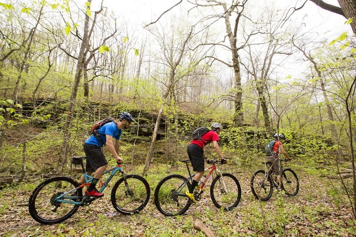
Upper Buffalo Wilderness Trailhead
Arkansas 21Mountain Biking! Spectacular trails
https://www.mtbproject.com/trail/7002912/upper-buffalo-headwaters-imba-epic
Fire Mountain Loop
https://www.mtbproject.com/trail/7000987/fire-tower-loop-trail
Trail Overview
This trail is a good test of your off-road skills. It has many elevation changes and obstacles that will test your equipment. The lower areas have several water crossings and some very deep mud bog areas. Choose your line carefully. The trail is prone to wash-outs and has plenty of deep gutters. The northern end reaches HWY 23 at West Fly Gap Road. The southeastern connection is on Morgan Mountain Road. There are several other trails to explore along the way, as well as two fun waterfalls that make for a good stop to refresh. Recovery equipment is a must when traveling this trail. The designated trail has moved in some areas and will remain moved due to natural events. This is one of the longer, more difficult trails to ride in the area.
Difficulty
The trails is moderate for 60% on the lower area along Mountain Creek. The northern 20% of the trail is very tight and rough with very narrow area's more suited to SxS but a short wheelbase 4x4 can run the trail. The southern 20% is very rutted and washed out with no bypass area.
Hanging Rock
Trail Overview
This trail is a good test of your off-road skills. It has many elevation changes and obstacles that will test your equipment. The lower areas have several water crossings and some very deep mud bog areas. Choose your line carefully. The trail is prone to wash-outs and has plenty of deep gutters. The northern end reaches HWY 23 at West Fly Gap Road. The southeastern connection is on Morgan Mountain Road. There are several other trails to explore along the way, as well as two fun waterfalls that make for a good stop to refresh. Recovery equipment is a must when traveling this trail. The designated trail has moved in some areas and will remain moved due to natural events. This is one of the longer, more difficult trails to ride in the area.
Difficulty
The trails is moderate for 60% on the lower area along Mountain Creek. The northern 20% of the trail is very tight and rough with very narrow area's more suited to SxS but a short wheelbase 4x4 can run the trail. The southern 20% is very rutted and washed out with no bypass area.
Floating Rivers (Spring & Fall)
Raft, Kayak, Canoe rentals
https://byrdsadventurecenter.com/raft/
19 lokal ang nagrerekomenda
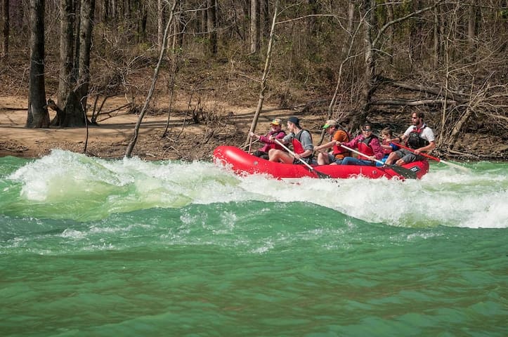
Byrd's Adventure Center
7037 Cass Oark RdRaft, Kayak, Canoe rentals
https://byrdsadventurecenter.com/raft/
Floating kayak, canoe, and raft rentals!
https://turnerbend.com/MulberryRiver.html
https://www.arownbackyard.com/2020/06/16/floating-byrds-to-turner-bend-on-the-mulberry-river/
14 lokal ang nagrerekomenda
Turner Bend Outfitters
20034 AR-23Floating kayak, canoe, and raft rentals!
https://turnerbend.com/MulberryRiver.html
https://www.arownbackyard.com/2020/06/16/floating-byrds-to-turner-bend-on-the-mulberry-river/
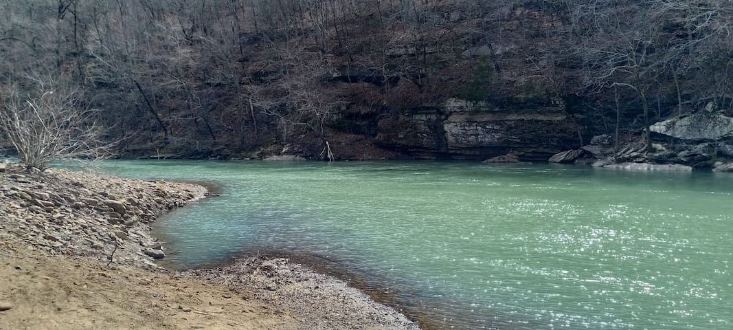
Floating the Mulberry River can be an adventurous day depending on the rivers levels! We have spent many a day enjoying the emerald tones of this hidden gem of a river nestled into the Ozarks! However, the Mulberry River is a fantastic body of water that is so wonderful to spend the day exploring, swimming, tubing and just plain watching the river flow! Mulberry River Campground. We offer River Tubes and Ice Chest Tubes available for rent.
When camping with us here at Mulberry River Outdoor Adventures you will find that we have one of the very BEST swimming holes along the Mulberry River!
Mulberry River Outdoor Adventures
6600 AR-215Floating the Mulberry River can be an adventurous day depending on the rivers levels! We have spent many a day enjoying the emerald tones of this hidden gem of a river nestled into the Ozarks! However, the Mulberry River is a fantastic body of water that is so wonderful to spend the day exploring, swimming, tubing and just plain watching the river flow! Mulberry River Campground. We offer River Tubes and Ice Chest Tubes available for rent.
When camping with us here at Mulberry River Outdoor Adventures you will find that we have one of the very BEST swimming holes along the Mulberry River!