
Marie's Guidebook
Sightseeing
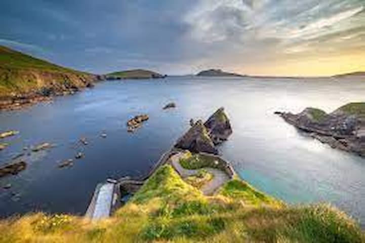
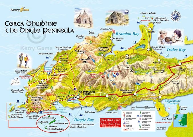
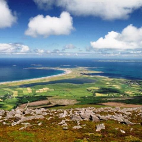
The Dingle Peninsula, on Ireland’s southwest Atlantic coast, is ringed by sandy beaches and craggy cliffs. Inland are rolling hills and mountains, including 952m Mount Brandon. The region’s an officially recognised bastion of Irish language and culture. Dunmore Head, mainland Ireland’s easternmost point, has views of the Blasket Islands, famous for Irish-language memoirs documenting rural life in the 1800s and 1900s.
71 lokal ang nagrerekomenda
Dingle Peninsula
The Dingle Peninsula, on Ireland’s southwest Atlantic coast, is ringed by sandy beaches and craggy cliffs. Inland are rolling hills and mountains, including 952m Mount Brandon. The region’s an officially recognised bastion of Irish language and culture. Dunmore Head, mainland Ireland’s easternmost point, has views of the Blasket Islands, famous for Irish-language memoirs documenting rural life in the 1800s and 1900s.
A beautiful forest area with a boardwalk all around the beautiful lake. A 10 minute drive from the house.
27 lokal ang nagrerekomenda
Glanteenassig Forest Park
A beautiful forest area with a boardwalk all around the beautiful lake. A 10 minute drive from the house.
Dingle town is a 20 minute drive from Maharees. You travel over the stunning beautiful Conors Pass. Dingle Town hosts a wide range of daily activities. There is a huge variety of pubs and restaurants to visit while there. Visit https://dingle-peninsula.ie/ to find our more.
114 lokal ang nagrerekomenda
Dingle
Dingle town is a 20 minute drive from Maharees. You travel over the stunning beautiful Conors Pass. Dingle Town hosts a wide range of daily activities. There is a huge variety of pubs and restaurants to visit while there. Visit https://dingle-peninsula.ie/ to find our more.
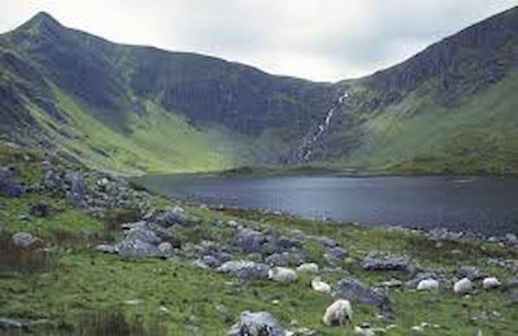
Loch a Dúin translates to ‘The Lake of the Fort’. Hidden at the bottom of the Conor Pass ( Kilmore Cross ) is a scenic self guided walk in a valley that is an archaeological treasure chest. It is the perfect walk for a family day out as it is suitable for all fitness levels and consists of mostly flat terrain. Enjoy a picnic beneath the waterfall and enjoy a breath taking view of the natural beauty.
Loughadoon
Loch a Dúin translates to ‘The Lake of the Fort’. Hidden at the bottom of the Conor Pass ( Kilmore Cross ) is a scenic self guided walk in a valley that is an archaeological treasure chest. It is the perfect walk for a family day out as it is suitable for all fitness levels and consists of mostly flat terrain. Enjoy a picnic beneath the waterfall and enjoy a breath taking view of the natural beauty.
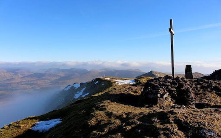
‘Mount Brandon’ or ‘Cnoc Bréanainn’ is considered one of the finest mountains in Ireland and is the highest mountain outside the MacGillycuddy’s Reeks. Located on the Dingle Peninsula, The Mount Brandon group runs north to south across the Peninsula, acting as a great divide between Kerry Gaeltacht of ‘Corca Dhuibhne’ to the west and Cloghane, Castlegregory and Tralee Bay to the east. ‘Mount Brandon’ is one of many holy mountains of Ireland with a well established ‘pilgrim route’. It derives its name from St Brendan, or ‘Brendan The Navigator’. He was a renowned figure in West Kerry, with a deep association with the locality and a large number of place names carry his name to this day. ‘Mount Brandon’s’ importance in early Christian times may also be due to the fact that, being so elevated, far west and visible from all around, it was the last place to view the sun setting.
32 lokal ang nagrerekomenda
Brandon Mountain
‘Mount Brandon’ or ‘Cnoc Bréanainn’ is considered one of the finest mountains in Ireland and is the highest mountain outside the MacGillycuddy’s Reeks. Located on the Dingle Peninsula, The Mount Brandon group runs north to south across the Peninsula, acting as a great divide between Kerry Gaeltacht of ‘Corca Dhuibhne’ to the west and Cloghane, Castlegregory and Tralee Bay to the east. ‘Mount Brandon’ is one of many holy mountains of Ireland with a well established ‘pilgrim route’. It derives its name from St Brendan, or ‘Brendan The Navigator’. He was a renowned figure in West Kerry, with a deep association with the locality and a large number of place names carry his name to this day. ‘Mount Brandon’s’ importance in early Christian times may also be due to the fact that, being so elevated, far west and visible from all around, it was the last place to view the sun setting.
Next stop America - drive up to the cliff edge and marville in the views across Brandon Bay to Maharees or stare out across the Atlantic towards America to see the cargo ships passing in the horizon. A fantastic spot to go and watch the sun set into the water.
7 lokal ang nagrerekomenda
Brandon Point
Next stop America - drive up to the cliff edge and marville in the views across Brandon Bay to Maharees or stare out across the Atlantic towards America to see the cargo ships passing in the horizon. A fantastic spot to go and watch the sun set into the water.
The Maharees Area & Heritage Trail
The Maharees Area
Stretching 5kms northwards into the Atlantic on the lee shore of the Dingle Peninsula, is a unique and special peninsula known as The Maharees - Na Machairí. Separating Brandon Bay from Tralee Bay, The Maharees tombola or sandy spit consists of sand dunes and wild beautiful beaches for much of its length and has a world-renowned reputation for its superb coastline, blue flag beaches, and large Atlantic swells.
Three villages or settlements, Fahamore, Kilshannig, and Candiha cluster on the earth and rocky ground around Scraggane Bay at the north end. At the tip lies Rough Point and out to sea across the Maharees Sound lie a cluster of uninhabited islands known as the Seven Hogs. The whole area of The Maharees lies low on the horizon with most of the peninsula close to sea level creating a special light and atmosphere.
A place of exceptional beauty, with its long uninterrupted beaches and dune system, The Maharees offers a wide variety of water activities such as surfing, windsurfing, waterskiing, kiteboarding, scuba diving, angling and canoeing. Equipment and instruction are available locally with all levels of experience catered for, a perfect day out for families wanting a fun or adventurous experience. For land based activities, try pony trekking along the beach or enjoy glorious walks on mile upon mile of white sandy beaches.
11 lokal ang nagrerekomenda
Maharees
The Maharees Area
Stretching 5kms northwards into the Atlantic on the lee shore of the Dingle Peninsula, is a unique and special peninsula known as The Maharees - Na Machairí. Separating Brandon Bay from Tralee Bay, The Maharees tombola or sandy spit consists of sand dunes and wild beautiful beaches for much of its length and has a world-renowned reputation for its superb coastline, blue flag beaches, and large Atlantic swells.
Three villages or settlements, Fahamore, Kilshannig, and Candiha cluster on the earth and rocky ground around Scraggane Bay at the north end. At the tip lies Rough Point and out to sea across the Maharees Sound lie a cluster of uninhabited islands known as the Seven Hogs. The whole area of The Maharees lies low on the horizon with most of the peninsula close to sea level creating a special light and atmosphere.
A place of exceptional beauty, with its long uninterrupted beaches and dune system, The Maharees offers a wide variety of water activities such as surfing, windsurfing, waterskiing, kiteboarding, scuba diving, angling and canoeing. Equipment and instruction are available locally with all levels of experience catered for, a perfect day out for families wanting a fun or adventurous experience. For land based activities, try pony trekking along the beach or enjoy glorious walks on mile upon mile of white sandy beaches.
Maharees Heritage Trail
The long history and scenic wonders of the Maharees – along with less obvious scenes of piracy and shipwrecks – will be charted in the Maharees Heritage Trail. The trail, which follows the outline of the outermost part of the Maharees peninsula, runs from Béal Geal (Sandy Bay) to the tSean Abhainn river that flows from Lough Gill, providing a source of fresh water over the long centuries that the Maharees has been inhabited.
Although The Maharees is now more commonly known as a summer retreat for caravanning holidaymakers, the heritage trail reveals that it has a very long and fascinating history, going back to the 5th Century monastic site at Oileán tSeannaigh founded by Saint Seanach.
In more recent times, many ships met their end off the Maharees, including the Nuestra Senora del Socorro of the Spanish Armada, various cargo vessels and the unfortunate East Indiaman ‘York’ which was wrecked by pirates in 1758. The flora and fauna of the fragile peninsula, which is listed as a Special Area of Conservation, is also outlined along the trail on signs beautifully illustrated by West Kerry artist Domhnall Ó Bric.
Click on this link for google maps directions to start of walk
www.google.ie/maps/dir/Castlegregory,+Martramane,+Co.+Kerry/52.2806163,-10.0253895/@52.2791124,-10.0299034,16.4z
(Car parking is available. Roads are quite rural and narrow so caution is advised.) click on this link for an outline of the walk itself https://www.plotaroute.com/route/968028
A pocket size map with interesting facts is available from Castlegregoy Information Centre in Castlegregoery, V92 FH32
11 lokal ang nagrerekomenda
Maharees
Maharees Heritage Trail
The long history and scenic wonders of the Maharees – along with less obvious scenes of piracy and shipwrecks – will be charted in the Maharees Heritage Trail. The trail, which follows the outline of the outermost part of the Maharees peninsula, runs from Béal Geal (Sandy Bay) to the tSean Abhainn river that flows from Lough Gill, providing a source of fresh water over the long centuries that the Maharees has been inhabited.
Although The Maharees is now more commonly known as a summer retreat for caravanning holidaymakers, the heritage trail reveals that it has a very long and fascinating history, going back to the 5th Century monastic site at Oileán tSeannaigh founded by Saint Seanach.
In more recent times, many ships met their end off the Maharees, including the Nuestra Senora del Socorro of the Spanish Armada, various cargo vessels and the unfortunate East Indiaman ‘York’ which was wrecked by pirates in 1758. The flora and fauna of the fragile peninsula, which is listed as a Special Area of Conservation, is also outlined along the trail on signs beautifully illustrated by West Kerry artist Domhnall Ó Bric.
Click on this link for google maps directions to start of walk
www.google.ie/maps/dir/Castlegregory,+Martramane,+Co.+Kerry/52.2806163,-10.0253895/@52.2791124,-10.0299034,16.4z
(Car parking is available. Roads are quite rural and narrow so caution is advised.) click on this link for an outline of the walk itself https://www.plotaroute.com/route/968028
A pocket size map with interesting facts is available from Castlegregoy Information Centre in Castlegregoery, V92 FH32
Bars & Restaurants
The Dingle Peninsula is renowned for its many bars and restaurants all serving top quality food & drinks.
Spillanes Bar & Restaurant, Maharees is less than 1 kilometer from the house. Open March to November they serve delish fresh local produce. https://www.spillanesbar.com/
21 lokal ang nagrerekomenda
Spillane's Bar & Restaurant
Spillanes Bar & Restaurant, Maharees is less than 1 kilometer from the house. Open March to November they serve delish fresh local produce. https://www.spillanesbar.com/
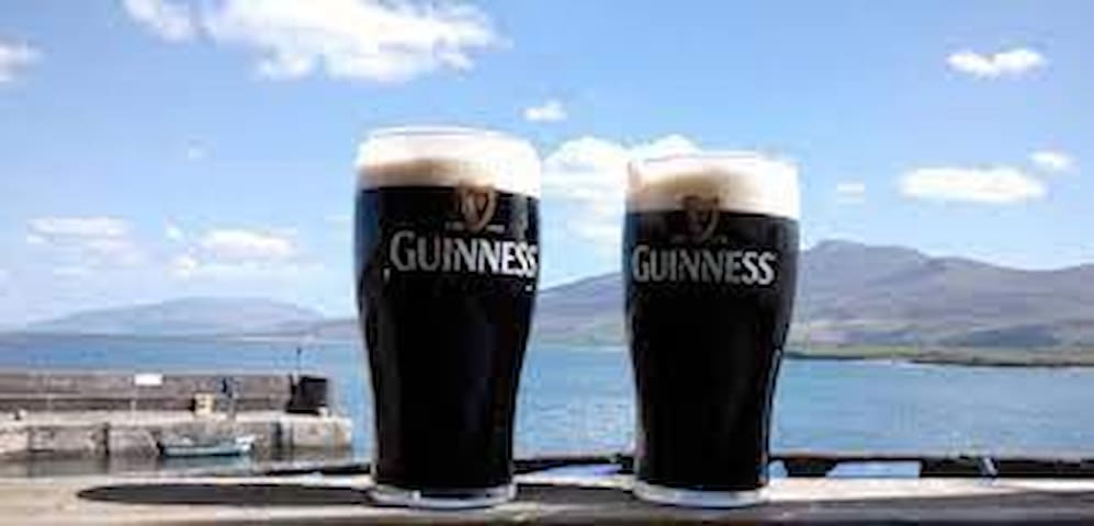
The Green Room Bar, Maharees, is just under 1kilometre away, where you can get a fine creamy pint of Guinness.
The Green Room
The Green Room Bar, Maharees, is just under 1kilometre away, where you can get a fine creamy pint of Guinness.
Located in Dingle the Fish Box serves Excellent fresh fish here with fresh cut chips from O'Connors Fruit & Veg who use Maharees grown potatoes.
25 lokal ang nagrerekomenda
The Fish Box / Flannery's Seafood Bar
Green StreetLocated in Dingle the Fish Box serves Excellent fresh fish here with fresh cut chips from O'Connors Fruit & Veg who use Maharees grown potatoes.
Pisces Restaurant
1 Strand StBeautiful locally sourced food served daily.
Enjoy a creamy Guiness while sitting on the pier looking out across Brandon Bay to Maharees. The fresh crab sandwich is a must to try here.
8 lokal ang nagrerekomenda
Murphy's Bar
Enjoy a creamy Guiness while sitting on the pier looking out across Brandon Bay to Maharees. The fresh crab sandwich is a must to try here.
Things to do
Afun day out in Maharees. RYA windsurf and surf school more info on www.jamieknox.com
8 lokal ang nagrerekomenda
Jamie Knox Watersports - Sandy Bay Centre
Sandy bayAfun day out in Maharees. RYA windsurf and surf school more info on www.jamieknox.com
A great family fun day out on the water also PADI dive-centre
check them out on : www.waterworld.ie
6 lokal ang nagrerekomenda
Waterworld Dive Centre
Sacraggane PierA great family fun day out on the water also PADI dive-centre
check them out on : www.waterworld.ie
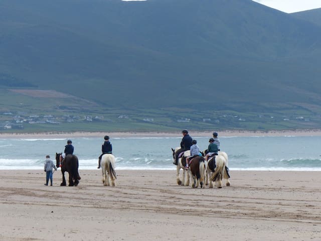
Book a horse riding trek along the scenic Wild Atlantic Way with O'Connors Trekking & Horse Riding http://www.beachhorseriding.com/
8 lokal ang nagrerekomenda
O'Connor's Trekking Horse Riding
Book a horse riding trek along the scenic Wild Atlantic Way with O'Connors Trekking & Horse Riding http://www.beachhorseriding.com/
Castlegregory Golf & Fishing club is a lovely 9-hole links course overlooking the surf at Brandon Bay.
www.castlegregorygolflinks.com
15 lokal ang nagrerekomenda
Castlegregory Golf Links
Castlegregory Golf & Fishing club is a lovely 9-hole links course overlooking the surf at Brandon Bay.
www.castlegregorygolflinks.com
Sandy Feet Farm is located a 10 minute drive from the house.
The farm has been in the family for more than 300 years - we thought it was time we shared it with others!
Depending on the time of year, baby farm animals are waiting to be cuddled and fed. Enjoy feeding the various rare breed farm animals, exploring the farm, playing in the playground or taking a trailer ride around the farm.
Check out the natural play and sensory garden or eating in our fabulous café. You are guaranteed to enjoy a fun-filled day out!
15 lokal ang nagrerekomenda
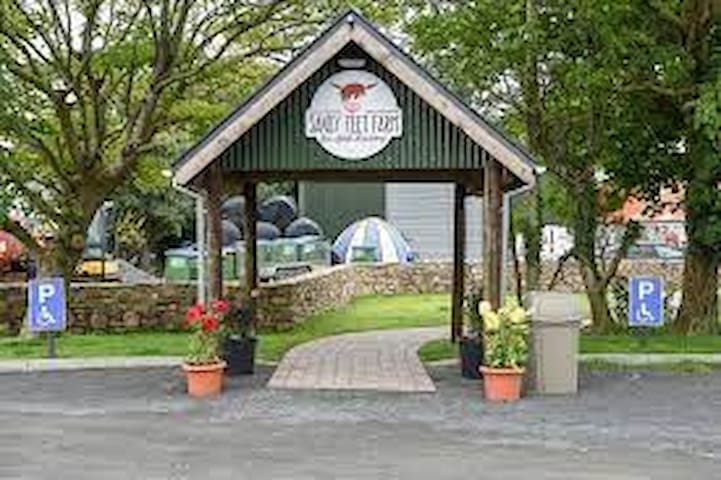
Sandy Feet Farm and Cafe
Sandy Feet Farm is located a 10 minute drive from the house.
The farm has been in the family for more than 300 years - we thought it was time we shared it with others!
Depending on the time of year, baby farm animals are waiting to be cuddled and fed. Enjoy feeding the various rare breed farm animals, exploring the farm, playing in the playground or taking a trailer ride around the farm.
Check out the natural play and sensory garden or eating in our fabulous café. You are guaranteed to enjoy a fun-filled day out!
Dingle Oceanworld
The WoodA great place to visit on a rainy day
Feel the magic at Dingle Pet Farm. Enjoy their friendly petting animals, historic stream walk, Go Kart track and Café with the lake view terrace
Dingle Eco Farm
Feel the magic at Dingle Pet Farm. Enjoy their friendly petting animals, historic stream walk, Go Kart track and Café with the lake view terrace