
Pine Mountain Club--A Mountain Retreat with a Faraway Feeling
Food Scene
Terrific mexican food-- large portions and reasonable prices. Friendly staff and a wide range of breakfast, lunch and dinner dishes. Located in the PMC Village
52 lokal ang nagrerekomenda
La Lena Mexican Restaurant
16236 Pine Valley LnTerrific mexican food-- large portions and reasonable prices. Friendly staff and a wide range of breakfast, lunch and dinner dishes. Located in the PMC Village
Need a latte? And a fresh bear claw [yes!], cinnamon roll or apple fritter? If it is lunch, then stop in here for homemade soup! Friendly, casual and fresh food.
55 lokal ang nagrerekomenda
Bear Claw Bakery
16215 Askin DrNeed a latte? And a fresh bear claw [yes!], cinnamon roll or apple fritter? If it is lunch, then stop in here for homemade soup! Friendly, casual and fresh food.
Wonderful pizza from a family that has been serving our mountain community for 30+ years. Try the Diablo if you like spicy! Amazing pizza with jalapenos and pineapple. Located in Frazier Park but worth the drive. They will deliver at the "Y" turnoff if you want. http://places.singleplatform.com/caveman-caveys-pizza/menu?ref=google
12 lokal ang nagrerekomenda
Caveman Cavey's Pizza
3620 Mt Pinos WayWonderful pizza from a family that has been serving our mountain community for 30+ years. Try the Diablo if you like spicy! Amazing pizza with jalapenos and pineapple. Located in Frazier Park but worth the drive. They will deliver at the "Y" turnoff if you want. http://places.singleplatform.com/caveman-caveys-pizza/menu?ref=google
Pine Mountain Pizza Co
16221 Askin DrLocal pizzeria serving a range of italian foods
Basecamp is a local gathering spot in the PMC Village for delicious coffee, tea, smoothies, beer, wine and food. Often music and other entertainment on weekends. https://www.pmcbasecampcafe.com/
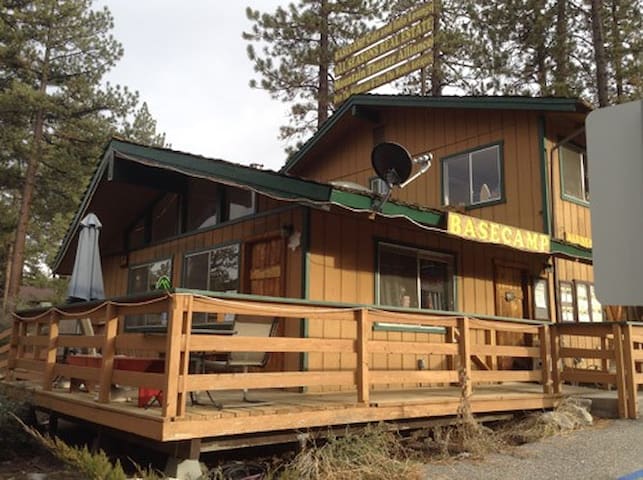
16311 Askin Dr
16311 Askin DriveBasecamp is a local gathering spot in the PMC Village for delicious coffee, tea, smoothies, beer, wine and food. Often music and other entertainment on weekends. https://www.pmcbasecampcafe.com/
Local pub and grub: https://www.facebook.com/pages/The%20Perch%2016200%20Mil%20Potrero%20Hwy%20Pine%20Mountain%20Club%20California/2332942660285043/
35 lokal ang nagrerekomenda
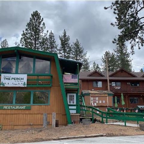
The Perch
16200 Mil Potrero HwyLocal pub and grub: https://www.facebook.com/pages/The%20Perch%2016200%20Mil%20Potrero%20Hwy%20Pine%20Mountain%20Club%20California/2332942660285043/
Arts & Culture
There are restored adobes from the original fort and the park’s museum features exhibits on army life and local history. The park also has a number of beautiful 400 year-old valley oak trees.
6 lokal ang nagrerekomenda
Fort Tejon State Historical Park
4201 Fort Tejon RdThere are restored adobes from the original fort and the park’s museum features exhibits on army life and local history. The park also has a number of beautiful 400 year-old valley oak trees.
A 260-acre park featuring world-class roller coasters and over 100 rides, games and attractions. FUN and thrills!
716 lokal ang nagrerekomenda
Six Flags Magic Mountain
26101 Magic Mountain PkwyA 260-acre park featuring world-class roller coasters and over 100 rides, games and attractions. FUN and thrills!
This 25-acre water park featuring more than 23 slides and attractions. Six Flags Hurricane Harbor is the gold standard for thrilling water parks
73 lokal ang nagrerekomenda
Six Flags Hurricane Harbor
26101 Magic Mountain PkwyThis 25-acre water park featuring more than 23 slides and attractions. Six Flags Hurricane Harbor is the gold standard for thrilling water parks
Sightseeing
For ATV and motorcycle enthusiasts. Hungry Valley SVRA is the third largest unit of California State Park's Off-Highway Motor Vehicle Recreation Division. Located in the Tejon Pass north of Los Angeles and along the Interstate 5 corridor, Hungry Valley offers 19,000 acres and more than 130 miles of scenic trails for motorcycle, All-Terrain Vehicles (ATV), dune buggies, and 4x4 recreation. All levels of OHV operator skills will be challenged by the wide variety of terrain and trails at Hungry Valley SVRA.
Elevations at Hungry Valley range from 3,000 to nearly 6,000 feet. Occasional snowfalls occur during the winter. Summers are most often hot, dry and dusty. The most pleasant times of the year for OHV fun are during the Spring and Fall months when the temperatures are mild and occasional rain showers make for good traction and reduced dust. Nighttime temperatures often drop below freezing in the Spring and Fall, as well as during the Winter. See: http://ohv.parks.ca.gov/?page_id=1192
9 lokal ang nagrerekomenda
Hungry Valley State Vehicular Recreation Area
5301 Ralphs Ranch RdFor ATV and motorcycle enthusiasts. Hungry Valley SVRA is the third largest unit of California State Park's Off-Highway Motor Vehicle Recreation Division. Located in the Tejon Pass north of Los Angeles and along the Interstate 5 corridor, Hungry Valley offers 19,000 acres and more than 130 miles of scenic trails for motorcycle, All-Terrain Vehicles (ATV), dune buggies, and 4x4 recreation. All levels of OHV operator skills will be challenged by the wide variety of terrain and trails at Hungry Valley SVRA.
Elevations at Hungry Valley range from 3,000 to nearly 6,000 feet. Occasional snowfalls occur during the winter. Summers are most often hot, dry and dusty. The most pleasant times of the year for OHV fun are during the Spring and Fall months when the temperatures are mild and occasional rain showers make for good traction and reduced dust. Nighttime temperatures often drop below freezing in the Spring and Fall, as well as during the Winter. See: http://ohv.parks.ca.gov/?page_id=1192
At 8,847 feet in elevation, Mount Pinos is located in the Los Padres National Forest. Best place to see stars in So. California. The hike to the top is about two miles along a wide access road shaded by pine trees much of the way. It is a fairly easy hike, with no significant challenges. Easy enough for kids and adults alike, though at this elevation your breathing may be a bit more labored than normal.
Take a deep breath of fresh air as you experience the 50th highest and 11th most topographically prominent summit in California.
29 lokal ang nagrerekomenda
Mount Pinos
At 8,847 feet in elevation, Mount Pinos is located in the Los Padres National Forest. Best place to see stars in So. California. The hike to the top is about two miles along a wide access road shaded by pine trees much of the way. It is a fairly easy hike, with no significant challenges. Easy enough for kids and adults alike, though at this elevation your breathing may be a bit more labored than normal.
Take a deep breath of fresh air as you experience the 50th highest and 11th most topographically prominent summit in California.
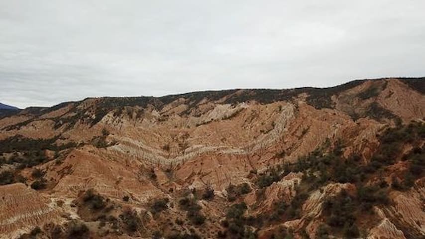
Cerro Noroeste is a mountain located in Kern County within the Los Padres National Forest. It has an elevation of 8286 feet (2,526 meters) and is the fourth highest mountain in the area. Mount Pinos, Sawmill Mountain, and neighboring Grouse Mountain are higher in altitude.
Cerro Noroeste is surrounded by the Chumash Wilderness to the south and west but the peak itself is not actually within the wilderness area. The United States Congress designated the Chumash Wilderness in 1992. I believe Chumash is pronounced "choo-mosh".
The summit can be reached by a paved road named Cerro Noroeste Road (Forest Route 9N27). As you drive up the mountain you can enjoy spectacular views of the Carrizo Plain to the north, Cuyama Valley, Quatal and Apache Canyons to the west, as well as views of the San Joaquin valley to the east and Lockwood Valley and Sespe ranges to the south.
The road is closed every winter after early snowfalls. The snow gate is usually reopened in May when the road becomes passable again.
Tucked away high atop Cerro Noroeste you will find solitude, serenity and unsurpassed scenery as you lose yourself in a pleasant grove of Jeffrey pines at theCampo Alto campground ("high camp"). Campsites are spacious, the air smells pine-sweet, and you will enjoy end-of-the-road privacy.
Cerro Noroeste
Cerro Noroeste is a mountain located in Kern County within the Los Padres National Forest. It has an elevation of 8286 feet (2,526 meters) and is the fourth highest mountain in the area. Mount Pinos, Sawmill Mountain, and neighboring Grouse Mountain are higher in altitude.
Cerro Noroeste is surrounded by the Chumash Wilderness to the south and west but the peak itself is not actually within the wilderness area. The United States Congress designated the Chumash Wilderness in 1992. I believe Chumash is pronounced "choo-mosh".
The summit can be reached by a paved road named Cerro Noroeste Road (Forest Route 9N27). As you drive up the mountain you can enjoy spectacular views of the Carrizo Plain to the north, Cuyama Valley, Quatal and Apache Canyons to the west, as well as views of the San Joaquin valley to the east and Lockwood Valley and Sespe ranges to the south.
The road is closed every winter after early snowfalls. The snow gate is usually reopened in May when the road becomes passable again.
Tucked away high atop Cerro Noroeste you will find solitude, serenity and unsurpassed scenery as you lose yourself in a pleasant grove of Jeffrey pines at theCampo Alto campground ("high camp"). Campsites are spacious, the air smells pine-sweet, and you will enjoy end-of-the-road privacy.
This 93,000 acre preserve is largest non-profit preserve on the West Coast. The preserve is an ecologically unique region where the Transverse Ranges, Coast Ranges, Sierra Nevada, western Mojave Desert and San Joaquin Valley converge. Due to elevation ranging from 640 to 6,005 feet, the preserve has an impressive array of landforms and habitats that serve as a critical landscape linkage and wildlife corridor between the Coast Ranges and Sierra Nevada. At 93,000 acres, Wind Wolves is the west coast's largest non-profit preserve. An important conservation outcome of TWC's ownership is that TWC led a Tejon Ranch Working Group of conservation organizations that resulted in a plan to double the target amount of conserved land on the neighboring Tejon Ranch to over 230,000 acres.
On the San Joaquin Valley floor, the preserve is a 30-square-mile veritable sea of grasslands with remnant stands of saltbush. These grasslands are home to the endangered San Joaquin kit fox and blunt-nosed leopard lizard, and one of the largest stands of the endangered Bakersfield cactus. Rolling grasslands rise from the valley floor and transition into classic California blue oak and valley oak savanna with extensive riparian wetlands. The oak savanna rises into juniper and pinyon forests that ascend into stands of ponderosa pine and big cone spruce. https://www.wildlandsconservancy.org/preserve_windwolves.html
42 lokal ang nagrerekomenda
Wind Wolves Preserve
16019 California 166This 93,000 acre preserve is largest non-profit preserve on the West Coast. The preserve is an ecologically unique region where the Transverse Ranges, Coast Ranges, Sierra Nevada, western Mojave Desert and San Joaquin Valley converge. Due to elevation ranging from 640 to 6,005 feet, the preserve has an impressive array of landforms and habitats that serve as a critical landscape linkage and wildlife corridor between the Coast Ranges and Sierra Nevada. At 93,000 acres, Wind Wolves is the west coast's largest non-profit preserve. An important conservation outcome of TWC's ownership is that TWC led a Tejon Ranch Working Group of conservation organizations that resulted in a plan to double the target amount of conserved land on the neighboring Tejon Ranch to over 230,000 acres.
On the San Joaquin Valley floor, the preserve is a 30-square-mile veritable sea of grasslands with remnant stands of saltbush. These grasslands are home to the endangered San Joaquin kit fox and blunt-nosed leopard lizard, and one of the largest stands of the endangered Bakersfield cactus. Rolling grasslands rise from the valley floor and transition into classic California blue oak and valley oak savanna with extensive riparian wetlands. The oak savanna rises into juniper and pinyon forests that ascend into stands of ponderosa pine and big cone spruce. https://www.wildlandsconservancy.org/preserve_windwolves.html
Quatal Canyon OHV Trail is a 23.5 kilometer lightly trafficked point-to-point trail located near Frazier Park, California that features badlands terrain. The trail is primarily used for off road driving and is best used from April until November. Dogs are also able to use this trail but must be kept on leash. https://www.alltrails.com/trail/us/california/quatal-canyon?u=m
Quatal Canyon
Quatal Canyon OHV Trail is a 23.5 kilometer lightly trafficked point-to-point trail located near Frazier Park, California that features badlands terrain. The trail is primarily used for off road driving and is best used from April until November. Dogs are also able to use this trail but must be kept on leash. https://www.alltrails.com/trail/us/california/quatal-canyon?u=m
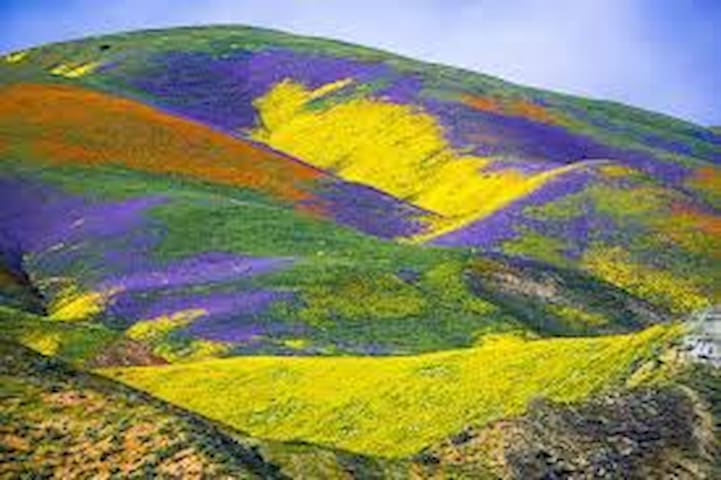
Three hundred years ago, California’s Central Valley was vast grassland where antelope and elk grazed and wildflowers swept the spring landscape. Today, amid urban and agriculture development, a remnant remains in the Carrizo Plain National Monument.
Carrizo Plain National Monument is one of the best kept secrets in California. Only a few hours from Los Angeles, the Carrizo Plain offers visitors a rare chance to be alone with nature. Some visitors say you can "hear the silence." The plain is home to diverse communities of wildlife and plant species including several listed as threatened or endangered and is an area culturally important to Native Americans.
This remote monument, traversed by the San Andreas Fault which has carved valleys, created and moved mountains, and yet up close, is seen in subtle alignment of ridges, ravines and normally dry ponds. Prominent features on the monument include the white alkali flats of Soda Lake, Painted Rock, vast open grasslands, and a broad plain rimmed by mountains. When conditions are right, numerous wildflowers can carpet the valley floor; although short lived it can be breathtaking.
15 lokal ang nagrerekomenda
Carrizo Plain National Monument
17495 Soda Lake RdThree hundred years ago, California’s Central Valley was vast grassland where antelope and elk grazed and wildflowers swept the spring landscape. Today, amid urban and agriculture development, a remnant remains in the Carrizo Plain National Monument.
Carrizo Plain National Monument is one of the best kept secrets in California. Only a few hours from Los Angeles, the Carrizo Plain offers visitors a rare chance to be alone with nature. Some visitors say you can "hear the silence." The plain is home to diverse communities of wildlife and plant species including several listed as threatened or endangered and is an area culturally important to Native Americans.
This remote monument, traversed by the San Andreas Fault which has carved valleys, created and moved mountains, and yet up close, is seen in subtle alignment of ridges, ravines and normally dry ponds. Prominent features on the monument include the white alkali flats of Soda Lake, Painted Rock, vast open grasslands, and a broad plain rimmed by mountains. When conditions are right, numerous wildflowers can carpet the valley floor; although short lived it can be breathtaking.
Payo sa lungsod
Huwag palampasin
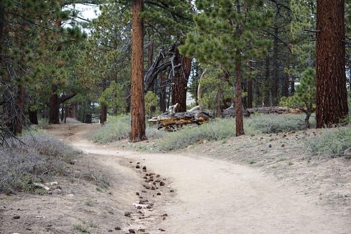
Getting out on our mountain trails!
Pine Mountain Club offers some great hiking and cycling. Some trails are easy; others are not. In any case, the thin air at 5,500+ feet will make any exercise in this area a challenge. Be sure to take water and to notify someone of your plans before you leave.
For descriptions, see: https://pinemountainclub.net/hiking-trails
Huwag palampasin
Fern's Lake/Fishing
Beautiful Fern’s Lake offers not only relaxing scenery and picnic areas, but catch-and-release fishing from its banks. The lake is home to a variety of species — such as trout, bluegill, bass and catfish to name a few. There are even a few red-eared slider aquatic turtles living in the lake. This spot is a very relaxing place to spend a summer or fall day.
Huwag palampasin
Pine Mountain Club Events
See what's happening locally at: https://pinemountainclub.net/web/pages/upcoming-events
Huwag palampasin
Pine Mountain Club Recreation
see all the possibilities at: https://pinemountainclub.net/web/pages/recreation