
Poona Farm Cottage - Guidebook by Rayleen & Brian
Beaches to Explore
Located in Coulta on the Eyre Peninsula, Greenly Beach is just an hour's drive away from Port Lincoln. It is a popular swimming and surfing beach, with waves averaging just over 1 m.
The beach is bordered by bluffs with some reef toward the centre. Greenly Beach is backed by continuous active sand dunes extending up to 1 km inland. The access road runs out to the southern end of Greenly beach and parallels the rear of the sand dunes, with 250 m high Mount Greenly immediately east.
Reference: Tourism SA

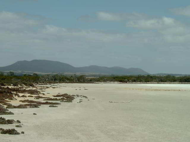
Greenly Beach
Located in Coulta on the Eyre Peninsula, Greenly Beach is just an hour's drive away from Port Lincoln. It is a popular swimming and surfing beach, with waves averaging just over 1 m.
The beach is bordered by bluffs with some reef toward the centre. Greenly Beach is backed by continuous active sand dunes extending up to 1 km inland. The access road runs out to the southern end of Greenly beach and parallels the rear of the sand dunes, with 250 m high Mount Greenly immediately east.
Reference: Tourism SA
Beach
Two and a half kilometers to the north is the first of the Coles Point beaches. Beach 957 is a 400 m long west facing sand beach, backed by 20 m high bluffs, with a vehicle track leading to the southern bluffs. The beach receives waves averaging up to 1 m, which break across a reef and rock filled 50 m wide surf zone, with a permanent rip draining the surf. On the northern side of the rocks is 600 m long beach 958, a straight west facing beach which receives waves averaging 1 m. These maintain a 50 m wide bar which is usually cut by two beach rips, together with some rocks along the beach. The vehicle track runs along the 20 m high bluffs behind the beach, with no formal foot access. It is bordered by a protruding bluff at the northern end, on the northern side of which is 200 m long beach 959, a pocket of sand, backed by the bluffs and partially fronted by reefs. Bluffs and a rock platform separate it from beach 960, which lies of the southern side of Coles Point. The beach is 500 m long, faces south and curves round slightly under 20 m high bluffs. There are bluff top car parks at either end, with the best access down the steep southern bluff.
Swimming
While all these beaches receive relatively low waves, their difficult foot access and the presence of rocks and reef make them moderately hazardous. Use care in accessing and swimming on any of these beaches.
Surfing
Usually only a heavy shorebreak on the more exposed beaches during higher waves.
Fishing
There are many good rock fishing spots, but again access can be difficult and watch for larger waves.
General
Most people visit this section of the coast for the views from the many lookouts, with only a few keen fishers using some of the beaches.
Reference: Beachsafe Website

Coles Point
Beach
Two and a half kilometers to the north is the first of the Coles Point beaches. Beach 957 is a 400 m long west facing sand beach, backed by 20 m high bluffs, with a vehicle track leading to the southern bluffs. The beach receives waves averaging up to 1 m, which break across a reef and rock filled 50 m wide surf zone, with a permanent rip draining the surf. On the northern side of the rocks is 600 m long beach 958, a straight west facing beach which receives waves averaging 1 m. These maintain a 50 m wide bar which is usually cut by two beach rips, together with some rocks along the beach. The vehicle track runs along the 20 m high bluffs behind the beach, with no formal foot access. It is bordered by a protruding bluff at the northern end, on the northern side of which is 200 m long beach 959, a pocket of sand, backed by the bluffs and partially fronted by reefs. Bluffs and a rock platform separate it from beach 960, which lies of the southern side of Coles Point. The beach is 500 m long, faces south and curves round slightly under 20 m high bluffs. There are bluff top car parks at either end, with the best access down the steep southern bluff.
Swimming
While all these beaches receive relatively low waves, their difficult foot access and the presence of rocks and reef make them moderately hazardous. Use care in accessing and swimming on any of these beaches.
Surfing
Usually only a heavy shorebreak on the more exposed beaches during higher waves.
Fishing
There are many good rock fishing spots, but again access can be difficult and watch for larger waves.
General
Most people visit this section of the coast for the views from the many lookouts, with only a few keen fishers using some of the beaches.
Reference: Beachsafe Website
Beach
The main Farm beach (943) extends north for 2 km from a sandy inflection point with the southern beach, up to the northern boundary bluffs, next to the boat ramp area, with the shacks and houses located on the backing bedrock slopes. The beach is exposed to low refracted ocean swell, which average less than 0.5 m, with calm conditions also common. Apart from the access road and shacks there are no facilities at the beach.
Swimming
Farm Beach is the most accessible and popular location, while Gallipoli is the more scenic. All beaches are relatively safe under normal low wave to calm conditions, though access and rocks are a hazard on the northern beaches.
Surfing
Usually too small, with only shorebreaks in larger swell.
Fishing
Most fishers launch their boats at Farm Beach to head out to the deeper reefs.
General
An accessible, relatively low energy section of coast, mainly frequented by boat fishers.
Reference: Beach Safe Website
8 lokal ang nagrerekomenda

Farm Beach
Beach
The main Farm beach (943) extends north for 2 km from a sandy inflection point with the southern beach, up to the northern boundary bluffs, next to the boat ramp area, with the shacks and houses located on the backing bedrock slopes. The beach is exposed to low refracted ocean swell, which average less than 0.5 m, with calm conditions also common. Apart from the access road and shacks there are no facilities at the beach.
Swimming
Farm Beach is the most accessible and popular location, while Gallipoli is the more scenic. All beaches are relatively safe under normal low wave to calm conditions, though access and rocks are a hazard on the northern beaches.
Surfing
Usually too small, with only shorebreaks in larger swell.
Fishing
Most fishers launch their boats at Farm Beach to head out to the deeper reefs.
General
An accessible, relatively low energy section of coast, mainly frequented by boat fishers.
Reference: Beach Safe Website
Beach
Beach 955 lies below 40 m high cliffs on the southern side of Frenchman Bluff. It is a 200 m long sliver of sand fronted by deeper reefs, with only low waves at the shore. While the road runs along the top of the bluffs the beach can only be accessed down the steep eastern bluffs. On the north side of the bluff is 550 m long, west-facing beach 956, a more exposed beach receiving waves between 0.5 and 1 m on average, which maintain a narrow attached bar and surf zone. However the beach is backed by steep 50 m high bluffs, with the best access down a gully at the northern end.
Swimming
While all these beaches receive relatively low waves, their difficult foot access and the presence of rocks and reef make them moderately hazardous. Use care in accessing and swimming on any of these beaches.
Surfing
Usually only a heavy shorebreak on the more exposed beaches during higher waves.
Fishing
There are many good rock fishing spots, but again access can be difficult and watch for larger waves.
General
Most people visit this section of the coast for the views from the many lookouts, with only a few keen fishers using some of the beaches.
Reference: Beach Safety Website

Frenchman Bluff
Beach
Beach 955 lies below 40 m high cliffs on the southern side of Frenchman Bluff. It is a 200 m long sliver of sand fronted by deeper reefs, with only low waves at the shore. While the road runs along the top of the bluffs the beach can only be accessed down the steep eastern bluffs. On the north side of the bluff is 550 m long, west-facing beach 956, a more exposed beach receiving waves between 0.5 and 1 m on average, which maintain a narrow attached bar and surf zone. However the beach is backed by steep 50 m high bluffs, with the best access down a gully at the northern end.
Swimming
While all these beaches receive relatively low waves, their difficult foot access and the presence of rocks and reef make them moderately hazardous. Use care in accessing and swimming on any of these beaches.
Surfing
Usually only a heavy shorebreak on the more exposed beaches during higher waves.
Fishing
There are many good rock fishing spots, but again access can be difficult and watch for larger waves.
General
Most people visit this section of the coast for the views from the many lookouts, with only a few keen fishers using some of the beaches.
Reference: Beach Safety Website
Sightseeing
Located in Coulta on the Eyre Peninsula, Greenly Beach is just an hour's drive away from Port Lincoln. It is a popular swimming and surfing beach, with waves averaging just over 1 m.
The beach is bordered by bluffs with some reef toward the centre. Greenly Beach is backed by continuous active sand dunes extending up to 1 km inland. The access road runs out to the southern end of Greenly beach and parallels the rear of the sand dunes, with 250 m high Mount Greenly immediately east.
Reference: Tourism SA

Greenly Beach Rockpool
Located in Coulta on the Eyre Peninsula, Greenly Beach is just an hour's drive away from Port Lincoln. It is a popular swimming and surfing beach, with waves averaging just over 1 m.
The beach is bordered by bluffs with some reef toward the centre. Greenly Beach is backed by continuous active sand dunes extending up to 1 km inland. The access road runs out to the southern end of Greenly beach and parallels the rear of the sand dunes, with 250 m high Mount Greenly immediately east.
Reference: Tourism SA
Known for its remote coastal scenery, the bays and coastline around the Coffin Bay National Park are ideal for boating, fishing, sailing, scuba diving and windsurfing. You can explore the park’s coastal landscapes of high windswept cliffs and massive dunes, pounding surf beaches and sheltered sandy bays.
At the southern end of the park is Yangie Bay, accessible by 2WD. It’s an ideal place to paddle your canoe, enjoy a bush picnic or explore a coastal bushwalking trail. Point Avoid and Golden Island lookout can also be reached by sealed road and you’ll be rewarded with spectacular island views along the way.
The pristine northern beaches of Coffin Bay National Park are only accessible by high-clearance 4WD. A favourite destination for anglers, birdwatchers and surfers, this remote and beautiful area offers several secluded camping areas with easy beach access.
COFFIN BAY NATIONAL PARK
Yangie Bay Walks
Walks start at Yangi Bay camping area – bitumen road from Coffin Bay
Black Springs Well hike – 4WD from Yangie Bay
Follows the coast around the headland overlooking sheltered Port Douglas. – 2 klms return – allow 40 minutes.
Black Rocks Hike – 4WD from Yangie Bay
To the rugged coastline of Avoid Bay with views overlooking Lake Damascus along the way – 12 klm return – allow 4 hours.
Beach Walks
Long Beach – the nearest to our town – access on your right just before you enter the National Park.
Almonta Beach (in the Coffin Bay National Park) – Not only a great surf-fishing beach but a great family one to walk along. Also explore around the southern corner of Point Avoid.
Avoid Bay Beach (in the Coffin Bay National Park) Walk down the boat ramp and explore this beach.
Gunyah Beach and Sand Dunes – 4WD required – Either drive through the sand dunes to the beach or leave your vehicle in the car park just before the start of the Dunes and walk across the dunes to this spectacular beach.
Reference: SA Tourism & Coffin Bay net /what-to-do-around-coffin-bay/walks-and-hikes/
18 lokal ang nagrerekomenda

Coffin Bay National Park
Known for its remote coastal scenery, the bays and coastline around the Coffin Bay National Park are ideal for boating, fishing, sailing, scuba diving and windsurfing. You can explore the park’s coastal landscapes of high windswept cliffs and massive dunes, pounding surf beaches and sheltered sandy bays.
At the southern end of the park is Yangie Bay, accessible by 2WD. It’s an ideal place to paddle your canoe, enjoy a bush picnic or explore a coastal bushwalking trail. Point Avoid and Golden Island lookout can also be reached by sealed road and you’ll be rewarded with spectacular island views along the way.
The pristine northern beaches of Coffin Bay National Park are only accessible by high-clearance 4WD. A favourite destination for anglers, birdwatchers and surfers, this remote and beautiful area offers several secluded camping areas with easy beach access.
COFFIN BAY NATIONAL PARK
Yangie Bay Walks
Walks start at Yangi Bay camping area – bitumen road from Coffin Bay
Black Springs Well hike – 4WD from Yangie Bay
Follows the coast around the headland overlooking sheltered Port Douglas. – 2 klms return – allow 40 minutes.
Black Rocks Hike – 4WD from Yangie Bay
To the rugged coastline of Avoid Bay with views overlooking Lake Damascus along the way – 12 klm return – allow 4 hours.
Beach Walks
Long Beach – the nearest to our town – access on your right just before you enter the National Park.
Almonta Beach (in the Coffin Bay National Park) – Not only a great surf-fishing beach but a great family one to walk along. Also explore around the southern corner of Point Avoid.
Avoid Bay Beach (in the Coffin Bay National Park) Walk down the boat ramp and explore this beach.
Gunyah Beach and Sand Dunes – 4WD required – Either drive through the sand dunes to the beach or leave your vehicle in the car park just before the start of the Dunes and walk across the dunes to this spectacular beach.
Reference: SA Tourism & Coffin Bay net /what-to-do-around-coffin-bay/walks-and-hikes/
Boating, fishing, beachcombing, swimming, bird watching, whale watching and nature walks are all popular activities in this park. A variety of designated campgrounds in the park offer easy access to the beaches, bays and walking trails.
Lincoln National Park overlooks Boston Bay, the largest natural harbour in Australia, with granite headlands, sheltered bays and scenic offshore islands. On the southern side of the park are the massive, wind-sculpted sand dunes of the Sleaford-Wanna dune system and the pounding surf of the Southern Ocean.
Reference: National Parks Website
Lincoln National Park
Boating, fishing, beachcombing, swimming, bird watching, whale watching and nature walks are all popular activities in this park. A variety of designated campgrounds in the park offer easy access to the beaches, bays and walking trails.
Lincoln National Park overlooks Boston Bay, the largest natural harbour in Australia, with granite headlands, sheltered bays and scenic offshore islands. On the southern side of the park are the massive, wind-sculpted sand dunes of the Sleaford-Wanna dune system and the pounding surf of the Southern Ocean.
Reference: National Parks Website
Mount Dutton Bay Woolshed
450 Woolshed DrMuseum and Café
Fishing
Luxury sailing experiences & private charter available
Sail out into the heart of beautiful Coffin Bay to feast on local seafood prepared fresh onboard by the captain and experience the best of our postcard beaches, marine wildlife and rugged National Park coastline.
Reference: Sunset Charters Coffin Bay
Sunset Charters
Luxury sailing experiences & private charter available
Sail out into the heart of beautiful Coffin Bay to feast on local seafood prepared fresh onboard by the captain and experience the best of our postcard beaches, marine wildlife and rugged National Park coastline.
Reference: Sunset Charters Coffin Bay
If you are a novice or a pro, a family or group at GT we have the charter to suit you.
Aboard "Full Rip" your skipper Daniel will ensure your trip is a safe and pleasurable one.
While aboard "Full Rip" you will experience the quickest and most comfortable ride from the sheltered waters of Coffin Bay and Farm Beach, out to and beyond Point Sir Isaac, to Greenly and Rocky Islands and the four Hummocks.
Reference: GT Fishing Charters
GT Fishing Charters
Morgan RoadIf you are a novice or a pro, a family or group at GT we have the charter to suit you.
Aboard "Full Rip" your skipper Daniel will ensure your trip is a safe and pleasurable one.
While aboard "Full Rip" you will experience the quickest and most comfortable ride from the sheltered waters of Coffin Bay and Farm Beach, out to and beyond Point Sir Isaac, to Greenly and Rocky Islands and the four Hummocks.
Reference: GT Fishing Charters
Minniribbie Farm, close to the pristine shores of Coffin Bay, Eyre Peninsula, South Australia is open to the public Monday to Saturday, 10.00 am - 5.00 pm for direct sales of free range pork and smallgoods. With a café (oozing character, complete with deck) and an antique shop (Jindihn Antiques) on site, it makes a great place for the whole family to visit.
Reference: Minniribbie Farm
Minniribbie Farm
187 Snapper Hill RdMinniribbie Farm, close to the pristine shores of Coffin Bay, Eyre Peninsula, South Australia is open to the public Monday to Saturday, 10.00 am - 5.00 pm for direct sales of free range pork and smallgoods. With a café (oozing character, complete with deck) and an antique shop (Jindihn Antiques) on site, it makes a great place for the whole family to visit.
Reference: Minniribbie Farm
A range of experience options
You will experience all the beauty of the pure and pristine coast line, but with more time to spot the seals at "The Brothers" islands and slow to enjoy the dolphins if they appear along the way. Surrounded by the Coffin Bay national park on one side and farming land on the other. The new boat is launched with intimate tables for mingling with family, friends or guests. Very large windows that can open on lovely days allow for you to turn and catch all the action as we motor the approximately 16km out to our oyster lease at the entrance to the Coffin Bay water way. You will up close see the vastness of the prime oyster growing area of the world famous Coffin Bay oysters. We will certainly visit our oyster farm and explain about farming our oysters and take the time to pluck fresh ones to open and enjoy. Can't get any fresher than that. If you would like to immerse yourself in the experience then the option to walk around in the water on the farm is available. In your bathers or waders if you prefer. BYO towel. We have some waders available to share. 1 dozen oysters per person. Your tour guide will be the oyster farmer who will happily share knowledge about oyster farming, its history and local knowledge of the area and explore the Coffin Bay water ways.
Reference: Experience Coffin Bay
Experience Coffin Bay
A range of experience options
You will experience all the beauty of the pure and pristine coast line, but with more time to spot the seals at "The Brothers" islands and slow to enjoy the dolphins if they appear along the way. Surrounded by the Coffin Bay national park on one side and farming land on the other. The new boat is launched with intimate tables for mingling with family, friends or guests. Very large windows that can open on lovely days allow for you to turn and catch all the action as we motor the approximately 16km out to our oyster lease at the entrance to the Coffin Bay water way. You will up close see the vastness of the prime oyster growing area of the world famous Coffin Bay oysters. We will certainly visit our oyster farm and explain about farming our oysters and take the time to pluck fresh ones to open and enjoy. Can't get any fresher than that. If you would like to immerse yourself in the experience then the option to walk around in the water on the farm is available. In your bathers or waders if you prefer. BYO towel. We have some waders available to share. 1 dozen oysters per person. Your tour guide will be the oyster farmer who will happily share knowledge about oyster farming, its history and local knowledge of the area and explore the Coffin Bay water ways.
Reference: Experience Coffin Bay
Hiking and Rock Climbing
Mount Greenly (dual name: Millapa) is a mountain in Australia located in the state of South Australia on the Eyre Peninsula in the gazetted locality of Coulta.[1] The top of Mount Greenly is 305 metres (1,001 ft) above sea level.[1]
Mount Greenly is a privately owned heritage listed land.
Head out on this 3.9-km out-and-back trail near Coulta, South Australia. Generally considered a moderately challenging route, it takes an average of 1 h 37 min to complete. This trail is great for hiking and walking, and it's unlikely you'll encounter many other people while exploring.
his is an adventurous trip up the rocky ridgeline of Mount Greenly near Coulta on the western coast of the Eyre Peninsula. While there isn't much of an official trail route-finding is straightforward; you just need to stay on the ridgeline. From the top enjoy sweeping 360-degree views out over the ocean and south over Coffin Bay.
alltrails /trail/australia/south-australia/mount-greenly-summit

Mount Greenly
Mount Greenly (dual name: Millapa) is a mountain in Australia located in the state of South Australia on the Eyre Peninsula in the gazetted locality of Coulta.[1] The top of Mount Greenly is 305 metres (1,001 ft) above sea level.[1]
Mount Greenly is a privately owned heritage listed land.
Head out on this 3.9-km out-and-back trail near Coulta, South Australia. Generally considered a moderately challenging route, it takes an average of 1 h 37 min to complete. This trail is great for hiking and walking, and it's unlikely you'll encounter many other people while exploring.
his is an adventurous trip up the rocky ridgeline of Mount Greenly near Coulta on the western coast of the Eyre Peninsula. While there isn't much of an official trail route-finding is straightforward; you just need to stay on the ridgeline. From the top enjoy sweeping 360-degree views out over the ocean and south over Coffin Bay.
alltrails /trail/australia/south-australia/mount-greenly-summit
Lake Greenly is a natural lake that covers a surface area of 22 square kilometres (8.5 sq mi), has an average depth of 4 metres (13 ft). Lake Greenly boasts a total water volume of 0.09 cubic kilometres (73,000 acre⋅ft), and has a total shore line of 22 kilometres (14 mi). The lake, which sits at an elevation of 30 metres (98 ft), drains a watershed that covers 399 square kilometres (154 sq mi).
wikiwand /en/Lake_Greenly
Lake Greenly
Lake Greenly is a natural lake that covers a surface area of 22 square kilometres (8.5 sq mi), has an average depth of 4 metres (13 ft). Lake Greenly boasts a total water volume of 0.09 cubic kilometres (73,000 acre⋅ft), and has a total shore line of 22 kilometres (14 mi). The lake, which sits at an elevation of 30 metres (98 ft), drains a watershed that covers 399 square kilometres (154 sq mi).
wikiwand /en/Lake_Greenly
Follow the Coffin Bay Oyster Walk as it meanders through the coastal vegetation and idyllic shoreline of Coffin Bay and Kellidie Bay, one of Australia's premier oyster growing destinations. The Oyster Walk follows the coastline between Long Beach in the west and Snapper Point in the east, passing the Coffin Bay boat ramp, town centre and jetty. A loop through the Kellidie Bay Conservation Park incorporates a climb up to the Coffin Bay Lookout where you are rewarded with sweeping views over the waterways.
The main walking trail is 8km long and can be completed as an entire walk or in shorter sections . The majority of the walk has a Grade 2 difficultly with a well signposted formed track and covers relatively flat coastal areas with rest points and minimal steps. The loop to the Coffin Bay Lookout is Grade 3 with some steep sections. A 300-metre section on Long Beach is a Grade 4 unformed beach track.
There is an additional trail which takes you from Snapper Point to Old Oyster Town. Old Oyster Town is the site of the original settlement dating back to the 1850s, and is located within the Kellidie Bay Conservation Park. Little remains of the original settlement with only a well and lavender bush marking the area. This section has not been graded for difficulty.
southaustralia /products/eyre-peninsula/attraction/coffin-bay-oyster-walk
walkingsa

Oyster Walk
Oyster WalkFollow the Coffin Bay Oyster Walk as it meanders through the coastal vegetation and idyllic shoreline of Coffin Bay and Kellidie Bay, one of Australia's premier oyster growing destinations. The Oyster Walk follows the coastline between Long Beach in the west and Snapper Point in the east, passing the Coffin Bay boat ramp, town centre and jetty. A loop through the Kellidie Bay Conservation Park incorporates a climb up to the Coffin Bay Lookout where you are rewarded with sweeping views over the waterways.
The main walking trail is 8km long and can be completed as an entire walk or in shorter sections . The majority of the walk has a Grade 2 difficultly with a well signposted formed track and covers relatively flat coastal areas with rest points and minimal steps. The loop to the Coffin Bay Lookout is Grade 3 with some steep sections. A 300-metre section on Long Beach is a Grade 4 unformed beach track.
There is an additional trail which takes you from Snapper Point to Old Oyster Town. Old Oyster Town is the site of the original settlement dating back to the 1850s, and is located within the Kellidie Bay Conservation Park. Little remains of the original settlement with only a well and lavender bush marking the area. This section has not been graded for difficulty.
southaustralia /products/eyre-peninsula/attraction/coffin-bay-oyster-walk
walkingsa
City/town information
Mount Dutton Bay is a coastal locality in the Eyre and Western region of South Australia, situated in the District Council of Lower Eyre Peninsula. The name and boundaries were formalised in October 2003 in respect of the long established local name which is derived from the body of water known as Mount Dutton Bay. The locality incorporates three older residential "shack sites": Mount Dutton Bay West, on Dolphin Drive, Mount Dutton Bay East, on Woolshed Drive, and Shelley Beach/Salt Creek, on Shelly Beach Road. It is part of the cadastral Hundred of Lake Wangary.
The historic Mount Dutton Bay Woolshed and Mount Dutton Bay Jetty are listed on the South Australian Heritage Register.
The woolshed and jetty were built by Eyre Peninsula pastoral pioneer Price Maurice to shear wool from his pastoral leases and transport it to markets; the jetty, the latter of the two, dates from 1881. The site was used as a hub for the wool industry until the 1950s; it has continued as a base for leisure activities thereafter.
The woolshed and adjacent shearers' quarters now house tourist accommodation, a museum, cafe and gallery; a caravan park has also been built alongside.
The Mount Dutton Bay Conservation Park is located on islands in Mount Dutton Bay and other adjoining bodies of water.
The Aboriginal Barngarla name for "Mount Dutton" is Miranda.
Reference: wikipedia /wiki/Mount_Dutton_Bay,_South_Australia
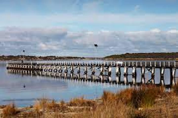
Mount Dutton Bay
Mount Dutton Bay is a coastal locality in the Eyre and Western region of South Australia, situated in the District Council of Lower Eyre Peninsula. The name and boundaries were formalised in October 2003 in respect of the long established local name which is derived from the body of water known as Mount Dutton Bay. The locality incorporates three older residential "shack sites": Mount Dutton Bay West, on Dolphin Drive, Mount Dutton Bay East, on Woolshed Drive, and Shelley Beach/Salt Creek, on Shelly Beach Road. It is part of the cadastral Hundred of Lake Wangary.
The historic Mount Dutton Bay Woolshed and Mount Dutton Bay Jetty are listed on the South Australian Heritage Register.
The woolshed and jetty were built by Eyre Peninsula pastoral pioneer Price Maurice to shear wool from his pastoral leases and transport it to markets; the jetty, the latter of the two, dates from 1881. The site was used as a hub for the wool industry until the 1950s; it has continued as a base for leisure activities thereafter.
The woolshed and adjacent shearers' quarters now house tourist accommodation, a museum, cafe and gallery; a caravan park has also been built alongside.
The Mount Dutton Bay Conservation Park is located on islands in Mount Dutton Bay and other adjoining bodies of water.
The Aboriginal Barngarla name for "Mount Dutton" is Miranda.
Reference: wikipedia /wiki/Mount_Dutton_Bay,_South_Australia
Our beautiful idyllic town of Coffin Bay, surrounded by sea and National Parks, overlooks the pristine waters of Port Douglas and Kellidie Bay, which are part of an extensive bay system that includes Little Douglas, Mount Dutton and Yangie Bays. In these bays, you will see numerous pods of dolphins whilst some of the islands are home to seals and sea lions and many breeding seabirds. Occasionally, you may even see a penguin.
Kangaroos and emus roam the town with land and sea birds in abundance and magnificent wildflowers, flowering shrubs and trees to be enjoyed.
Situated on the western tip of Southern Eyre Peninsula, Coffin Bay is 46 kilometres by road northwest of Port Lincoln. It boasts a steady growth in population and industry (aquaculture), with a permanent population of approximately 650, which swells to over 4,000 in the summer months.
Coffin Bay has an active commercial wharf in the town centre where you can watch the fishing boats unload their catches, including crayfish, pilchards, ocean jackets and sharks. There are also professional fishermen and abalone divers operating from the boat ramps. Their catches include octopus, sea urchins, sea snails, scallops, sand crabs, abalone, King George whiting and garfish. At the main boat ramp you will also see the oyster boats returning with baskets of the famous Coffin Bay oysters, from the many oyster leases within the bay system.
As the open ocean lies 21 kilometres from the town wharf, the many protected bays, channels and inlets offer ideal opportunities for fishing and all water activities.
Coffin Bay has all the facilities for you and your family to enjoy nature at its best.
WATER ACTIVITIES
Enjoy fabulous fishing via boat, beach, rock, or jetty, boating, sailing, canoeing, kayaking, surfing, water skiing, paddle boarding, swimming, snorkelling, diving, windsurfing, in fact all water sports. Hire facilities available. Enjoy one of many Coffin Bay tours.
LAND ACTIVITIES
There are walking trails with fabulous scenery, playgrounds, free public BBQs.
Explore the Coffin Bay National Park rugged coastline and sweeping beaches.
The Recreation Park on Morgan Road provides an oval with cricket pitch and practice footy goal posts, tennis and basketball courts, BMX track and skate park. Keys and nets are available from the IGA Supermarket.
Join the kangaroos and emus for a round of golf on the picturesque nine hole golf course with greens or try out the synthetic lawn bowl rink at the Coffin Bay Sporting Association, top of Giles Road.
A library facility at the Community Hall is open Tuesdays and Saturday mornings.
If you don’t feel active, then just sit back and enjoy the relaxed atmosphere of Coffin Bay – be sure to take in one of our spectacular sunrises or sunsets!
GENERAL FACILITIES
There is an IGA Supermaket and Beachcomber Cafe for food, petrol, ice, bait, ATMs, etc.
The business directory lists facilities available within the town and surrounds. Coffin Bay has a community church on Haggerty Street.
Free Wi-Fi is available on the foreshore.
DINING, CAFE AND TAKEAWAY
Coffin Bay has an amazing variety of venues for dining in or takeaway. Locations range from outstanding water views to cosy corners for coffee and cake. All showcase a variety of individual styles and dishes. Locally fresh seafood is sourced where possible and our world renoun Coffin Bay oysters are on the menu at many of these venues.
Bookings are appreciated at all venues.
INDOOR ENTERTAINMENT OPTIONS
In the local community hall, the library is open Saturday mornings. Local markets are monthly on Sundays. At 2 pm on Wednesdays there is social 8 Ball at the Sports Club.
DAY TRIPS IN THE REGION
There are also plenty of half day trips that you can enjoy to such places as Coffin Bay National Park, Kellidie Bay, Wangary, Mount Dutton Bay, Farm Beach, Little Douglas, Gallipoli Beach (site of the filming of Gallipoli with Mel Gibson), Frenchmans, Coles Point, Greenly Beach, Port Lincoln, Cummins, Todd Reservoir, the animal farm, tuna farms, museums, wineries, etc. with full day trips to Point Sir Isaac (4WD only), Lincoln National Park, Whalers Way, Halls Bay, Lake Hamilton, Sheringa, Locks Well, Elliston, Talia Caves, Venus Bay and many more.
COFFIN BAY’S WEATHER
Coffin Bay experiences a delightful Mediterranean climate with summers in the high 20ºs, lovely autumns, ranging from high teens to mid 20ºs.
Winter temperatures are in the mid-teens, while spring is generally sunny with some afternoons being quite breezy, temperatures ranging from high teens to low 20ºs.
Average rainfall is about 500mm, falling mainly during the winter months.
Reference: coffinbay net /welcome-to-coffin-bay/
15 lokal ang nagrerekomenda

Coffin Bay
Our beautiful idyllic town of Coffin Bay, surrounded by sea and National Parks, overlooks the pristine waters of Port Douglas and Kellidie Bay, which are part of an extensive bay system that includes Little Douglas, Mount Dutton and Yangie Bays. In these bays, you will see numerous pods of dolphins whilst some of the islands are home to seals and sea lions and many breeding seabirds. Occasionally, you may even see a penguin.
Kangaroos and emus roam the town with land and sea birds in abundance and magnificent wildflowers, flowering shrubs and trees to be enjoyed.
Situated on the western tip of Southern Eyre Peninsula, Coffin Bay is 46 kilometres by road northwest of Port Lincoln. It boasts a steady growth in population and industry (aquaculture), with a permanent population of approximately 650, which swells to over 4,000 in the summer months.
Coffin Bay has an active commercial wharf in the town centre where you can watch the fishing boats unload their catches, including crayfish, pilchards, ocean jackets and sharks. There are also professional fishermen and abalone divers operating from the boat ramps. Their catches include octopus, sea urchins, sea snails, scallops, sand crabs, abalone, King George whiting and garfish. At the main boat ramp you will also see the oyster boats returning with baskets of the famous Coffin Bay oysters, from the many oyster leases within the bay system.
As the open ocean lies 21 kilometres from the town wharf, the many protected bays, channels and inlets offer ideal opportunities for fishing and all water activities.
Coffin Bay has all the facilities for you and your family to enjoy nature at its best.
WATER ACTIVITIES
Enjoy fabulous fishing via boat, beach, rock, or jetty, boating, sailing, canoeing, kayaking, surfing, water skiing, paddle boarding, swimming, snorkelling, diving, windsurfing, in fact all water sports. Hire facilities available. Enjoy one of many Coffin Bay tours.
LAND ACTIVITIES
There are walking trails with fabulous scenery, playgrounds, free public BBQs.
Explore the Coffin Bay National Park rugged coastline and sweeping beaches.
The Recreation Park on Morgan Road provides an oval with cricket pitch and practice footy goal posts, tennis and basketball courts, BMX track and skate park. Keys and nets are available from the IGA Supermarket.
Join the kangaroos and emus for a round of golf on the picturesque nine hole golf course with greens or try out the synthetic lawn bowl rink at the Coffin Bay Sporting Association, top of Giles Road.
A library facility at the Community Hall is open Tuesdays and Saturday mornings.
If you don’t feel active, then just sit back and enjoy the relaxed atmosphere of Coffin Bay – be sure to take in one of our spectacular sunrises or sunsets!
GENERAL FACILITIES
There is an IGA Supermaket and Beachcomber Cafe for food, petrol, ice, bait, ATMs, etc.
The business directory lists facilities available within the town and surrounds. Coffin Bay has a community church on Haggerty Street.
Free Wi-Fi is available on the foreshore.
DINING, CAFE AND TAKEAWAY
Coffin Bay has an amazing variety of venues for dining in or takeaway. Locations range from outstanding water views to cosy corners for coffee and cake. All showcase a variety of individual styles and dishes. Locally fresh seafood is sourced where possible and our world renoun Coffin Bay oysters are on the menu at many of these venues.
Bookings are appreciated at all venues.
INDOOR ENTERTAINMENT OPTIONS
In the local community hall, the library is open Saturday mornings. Local markets are monthly on Sundays. At 2 pm on Wednesdays there is social 8 Ball at the Sports Club.
DAY TRIPS IN THE REGION
There are also plenty of half day trips that you can enjoy to such places as Coffin Bay National Park, Kellidie Bay, Wangary, Mount Dutton Bay, Farm Beach, Little Douglas, Gallipoli Beach (site of the filming of Gallipoli with Mel Gibson), Frenchmans, Coles Point, Greenly Beach, Port Lincoln, Cummins, Todd Reservoir, the animal farm, tuna farms, museums, wineries, etc. with full day trips to Point Sir Isaac (4WD only), Lincoln National Park, Whalers Way, Halls Bay, Lake Hamilton, Sheringa, Locks Well, Elliston, Talia Caves, Venus Bay and many more.
COFFIN BAY’S WEATHER
Coffin Bay experiences a delightful Mediterranean climate with summers in the high 20ºs, lovely autumns, ranging from high teens to mid 20ºs.
Winter temperatures are in the mid-teens, while spring is generally sunny with some afternoons being quite breezy, temperatures ranging from high teens to low 20ºs.
Average rainfall is about 500mm, falling mainly during the winter months.
Reference: coffinbay net /welcome-to-coffin-bay/
Discover Port Lincoln, The Seafood Capital of Australia
Port Lincoln is situated on Boston Bay, one of the largest protected natural harbours in the world and three times the size of Sydney Harbour and is part of the Eyre Peninsula.
The Eyre Peninsula is the traditional home to the Barngarla (Port Lincoln area), Nauo on the Southern Side, and Wirangu peoples further up the far west coast.
Matthew Flinders came to the area in 1802 and named it Port Lincoln, it was settled by white man in 1839. Port Lincoln today is a vibrant regional centre and the perfect base from which to explore the Southern Eyre Peninsula.
Incredible seafood, beautiful wines, fantastic ocean adventures, wonderful wildlife experiences, award-winning local tours, and an exhaustive range of things to see and do in both Port Lincoln and the surrounding towns will keep your days packed.
Reference: portlincoln /towns/port-lincoln/
21 lokal ang nagrerekomenda

Port Lincoln
Discover Port Lincoln, The Seafood Capital of Australia
Port Lincoln is situated on Boston Bay, one of the largest protected natural harbours in the world and three times the size of Sydney Harbour and is part of the Eyre Peninsula.
The Eyre Peninsula is the traditional home to the Barngarla (Port Lincoln area), Nauo on the Southern Side, and Wirangu peoples further up the far west coast.
Matthew Flinders came to the area in 1802 and named it Port Lincoln, it was settled by white man in 1839. Port Lincoln today is a vibrant regional centre and the perfect base from which to explore the Southern Eyre Peninsula.
Incredible seafood, beautiful wines, fantastic ocean adventures, wonderful wildlife experiences, award-winning local tours, and an exhaustive range of things to see and do in both Port Lincoln and the surrounding towns will keep your days packed.
Reference: portlincoln /towns/port-lincoln/
Restaurants & Cafe's
The best location in Coffin Bay to enjoy our fabulous, fresh and world famous oysters, right on the waters edge!
Oysters with a view!
Oyster HQ has the best waterfront view in Coffin Bay, right on the waters edge! Enjoy our famous and fabulously fresh Coffin Bay Oysters on the deck overlooking our beautiful pristine bay, with a bottle of bubbly.
Fresh Eyre Peninsula Seafood dining at it’s absolute best!
We feature a tapas style grazing menu, with apertizer sized tasting plates, designed to be shared, so you can enjoy a variety of tastes and options. The menu changes frequently depending on what is in season, and available locally, so there is always something new and exciting to try. It features both seafood and non seafood options.
Reference: oysterfarmtours /oyster-hq-venue
14 lokal ang nagrerekomenda
Oyster HQ
100 EsplanadeThe best location in Coffin Bay to enjoy our fabulous, fresh and world famous oysters, right on the waters edge!
Oysters with a view!
Oyster HQ has the best waterfront view in Coffin Bay, right on the waters edge! Enjoy our famous and fabulously fresh Coffin Bay Oysters on the deck overlooking our beautiful pristine bay, with a bottle of bubbly.
Fresh Eyre Peninsula Seafood dining at it’s absolute best!
We feature a tapas style grazing menu, with apertizer sized tasting plates, designed to be shared, so you can enjoy a variety of tastes and options. The menu changes frequently depending on what is in season, and available locally, so there is always something new and exciting to try. It features both seafood and non seafood options.
Reference: oysterfarmtours /oyster-hq-venue
1802 Oyster Bar is situated in beautiful Coffin Bay overlooking the pristine waters and oyster leases that have made the town, and its oysters world famous. Utilising the freshest, highest quality local seafood and produce on their doorstep. It also boast a fully licensed bar and an impressive South Australian wine list. 1802 Oyster Bar – Coffin Bay is the place to be for both locals and tourists wanting to sample the very best the Eyre Peninsula has to offer.
Reference: Trip Advisor
11 lokal ang nagrerekomenda

1802 Oyster Bar and Bistro
61 Esplanade1802 Oyster Bar is situated in beautiful Coffin Bay overlooking the pristine waters and oyster leases that have made the town, and its oysters world famous. Utilising the freshest, highest quality local seafood and produce on their doorstep. It also boast a fully licensed bar and an impressive South Australian wine list. 1802 Oyster Bar – Coffin Bay is the place to be for both locals and tourists wanting to sample the very best the Eyre Peninsula has to offer.
Reference: Trip Advisor
The Marble Range Community & Sports Centre is home to the Marble Range Football Club, the Southern Eyre South Cricket Club and the Ranges Tennis Club.
Open from 5.00pm Tuesdays, Thursdays and Saturdays.
Summer teas available on Thursdays and Saturdays till April.
Great facilities and family friendly!

Marble Range Football Club
Flinders HighwayThe Marble Range Community & Sports Centre is home to the Marble Range Football Club, the Southern Eyre South Cricket Club and the Ranges Tennis Club.
Open from 5.00pm Tuesdays, Thursdays and Saturdays.
Summer teas available on Thursdays and Saturdays till April.
Great facilities and family friendly!
CUISINES
Seafood, Cafe, Australian
MEALS
Lunch, Brunch, Drinks, Breakfast
FEATURES
Takeout, Outdoor Seating, Seating, Wheelchair Accessible, Serves Alcohol

Beachcomber
113 EsplanadeCUISINES
Seafood, Cafe, Australian
MEALS
Lunch, Brunch, Drinks, Breakfast
FEATURES
Takeout, Outdoor Seating, Seating, Wheelchair Accessible, Serves Alcohol
he Club is situated directly on the picturesque Coffin Bay foreshore surrounded by lawns. We cater for the children with an inside area to play and a playground just a short walk away. It is a great spot for the family to enjoy. Trailer sailors are welcome to tie up at the Yacht Club jetty and shower/toilet facilities are available for use. It hosts a Sunday sailing program during the summer months, the bay currents providing a challenge for all sailing abilities.
Home style meals are served by a team of volunteers and our amazing chef Friday and Sunday evenings. A simple meal of “Fish and Chips” is served Wednesday nights, with choices of fish. All meals are served from 6pm.
The menu is reasonably priced, offering meat and fish dishes.
The Bar is also open (same nights) from 5pm. Happy Hour specials are offered Friday night 6pm to 7pm. The Bar offers a large range of red and white wines (including local) and a selection of beer and spirits.
Reference: coffinbayyachtclub
Coffin Bay Yacht Club
146 Esplanadehe Club is situated directly on the picturesque Coffin Bay foreshore surrounded by lawns. We cater for the children with an inside area to play and a playground just a short walk away. It is a great spot for the family to enjoy. Trailer sailors are welcome to tie up at the Yacht Club jetty and shower/toilet facilities are available for use. It hosts a Sunday sailing program during the summer months, the bay currents providing a challenge for all sailing abilities.
Home style meals are served by a team of volunteers and our amazing chef Friday and Sunday evenings. A simple meal of “Fish and Chips” is served Wednesday nights, with choices of fish. All meals are served from 6pm.
The menu is reasonably priced, offering meat and fish dishes.
The Bar is also open (same nights) from 5pm. Happy Hour specials are offered Friday night 6pm to 7pm. The Bar offers a large range of red and white wines (including local) and a selection of beer and spirits.
Reference: coffinbayyachtclub
Yarnbala
146 EsplanadeCoffin Bay Hotel
Shepperd AvenueCoffin Bay Pizza & Takeaway
61 EsplanadeActivities
Coffin Bay Golf Club
Giles RoadPort Lincoln Golf Club
Coffin Bay Scuba Co.
2 EsplanadeEP Boat Hire
67 West Bay RoadGroceries & Fuel
IGA Coffin Bay
151 EsplanadeCummins Takeaway & Deli
62 Bruce TerraceIGA Cummins
42-44 Railway Terrace