
LONE PINE GUIDEBOOK
PLACES TO EAT
Merry Go Round
212 S Main StGreat Chinese food
Stop in for a bite at this eclectic cafe adorned with old photos, an antique stove and western gear. We like the spaghetti and bread here!
Totem Cafe
131 S Main StStop in for a bite at this eclectic cafe adorned with old photos, an antique stove and western gear. We like the spaghetti and bread here!
Rustic yet refined American eatery serving seafood, pasta and charbroiled steaks, plus wine and spirits.
18 lokal ang nagrerekomenda
Seasons Restaurant
206 S Main StRustic yet refined American eatery serving seafood, pasta and charbroiled steaks, plus wine and spirits.
Jake's Saloon
119 N Main StLocal bar that will transport you back to the old wild west.
Great breakfast and lunch! Great service. Cute wall full of caricatures of rock formations.
20 lokal ang nagrerekomenda
Alabama Hills Cafe & Bakery
111 W Post StGreat breakfast and lunch! Great service. Cute wall full of caricatures of rock formations.
Lone Pine Smokehouse
325 S Main StIf you like BBQ, this is the place in Lone Pine!
Pizza Factory
301 S Main StThe Grill
446 S Main StAmerican and Seafood in a nice setting!
PLACES TO VISIT/ SIGHTSEEING
This is the gateway to Mount Whitney. Take Whitney Portal road all the way to the end where you will be greeted by towering granite cliffs, a waterfall and trails to the summit, Lone Pine Lake and access to John Muir Wilderness and the Sequoia National Park backcountry.
13 lokal ang nagrerekomenda
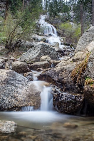
Whitney Portal
This is the gateway to Mount Whitney. Take Whitney Portal road all the way to the end where you will be greeted by towering granite cliffs, a waterfall and trails to the summit, Lone Pine Lake and access to John Muir Wilderness and the Sequoia National Park backcountry.
Take Horseshoe Meadow Road to the top when the road ends. This is the 10,000 feet high meadow with surrounding pine forest. 3 campgrounds are available on a first come first serve basis. Trails from Horseshoe meadow leads to Cottonwood Lakes 11.6 -12.4 miles roundtrip, Cottonwood Pass and Chicken Spring Lakes 7.4 - 9.0 miles Roundtrip. Trails also provide access to Golden Trout Wilderness and Sequoia Kings Canyon National Park backcountry and Pacific Coast Trail (PCT).
Horseshoe Meadow Campground
Take Horseshoe Meadow Road to the top when the road ends. This is the 10,000 feet high meadow with surrounding pine forest. 3 campgrounds are available on a first come first serve basis. Trails from Horseshoe meadow leads to Cottonwood Lakes 11.6 -12.4 miles roundtrip, Cottonwood Pass and Chicken Spring Lakes 7.4 - 9.0 miles Roundtrip. Trails also provide access to Golden Trout Wilderness and Sequoia Kings Canyon National Park backcountry and Pacific Coast Trail (PCT).
A remarkable display of nature’s handiwork in the Alabama Hills Recreational Area. Awe inspiring rock formations dot the landscape as far as the eye can see. You can’t help but be overcome by the sense of wonder and amazement at the sea of golden granite boulders rising up from the desert floor. Tucked away here and there are rock arches formed by time and the elements.
These massive boulders have been chiseled away leaving impressive holes through the center forming perfect archways. Most of the arches that have been found have and East/West view.
The Alabama Hills have become a popular setting for many movies and numerous commercials. Movie Road intersects with Whitney Portal Road about 3 miles west of Lone Pine.
21 lokal ang nagrerekomenda
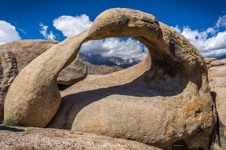
Alabama Hills
A remarkable display of nature’s handiwork in the Alabama Hills Recreational Area. Awe inspiring rock formations dot the landscape as far as the eye can see. You can’t help but be overcome by the sense of wonder and amazement at the sea of golden granite boulders rising up from the desert floor. Tucked away here and there are rock arches formed by time and the elements.
These massive boulders have been chiseled away leaving impressive holes through the center forming perfect archways. Most of the arches that have been found have and East/West view.
The Alabama Hills have become a popular setting for many movies and numerous commercials. Movie Road intersects with Whitney Portal Road about 3 miles west of Lone Pine.
In this below-sea-level basin, steady drought and record summer heat make Death Valley a land of extremes. Yet, each extreme has a striking contrast. Towering peaks are frosted with winter snow. Rare rainstorms bring vast fields of wildflowers. Lush oases harbor tiny fish and refuge for wildlife and humans. Despite its morbid name, a great diversity of life survives in Death Valley.
46 lokal ang nagrerekomenda
Death Valley
In this below-sea-level basin, steady drought and record summer heat make Death Valley a land of extremes. Yet, each extreme has a striking contrast. Towering peaks are frosted with winter snow. Rare rainstorms bring vast fields of wildflowers. Lush oases harbor tiny fish and refuge for wildlife and humans. Despite its morbid name, a great diversity of life survives in Death Valley.
Mount Whitney is the tallest mountain in California, as well as, the highest summit in the contiguous US and the Sierra Nevada with an elevation of 14,505 ft. You must obtain a permit in order to climb Whitney.
25 lokal ang nagrerekomenda
Mount Whitney
Mount Whitney is the tallest mountain in California, as well as, the highest summit in the contiguous US and the Sierra Nevada with an elevation of 14,505 ft. You must obtain a permit in order to climb Whitney.
Fossil Falls is a string of crazy rock formations made 440,000 years ago through a period of very active volcanism & melting glacial ice. Ancient Native American tribes also had a thriving community here about 12,000 years ago, so keep your eyes peeled for some obsidian flakes & metates.
13 lokal ang nagrerekomenda
Fossil Falls
Fossil Falls is a string of crazy rock formations made 440,000 years ago through a period of very active volcanism & melting glacial ice. Ancient Native American tribes also had a thriving community here about 12,000 years ago, so keep your eyes peeled for some obsidian flakes & metates.
The Little Lakes Basin is truly an extraordinary place. An easy trail ascends along a succession of gorgeous glacial carved lakes set amid pretty meadows framed by the spectacular 13,000-ft peaks of Bear Creek Spire, Mt. Dade, Mt. Abbot, Mt. Mills and Mt. Morgan. In summer, the snow is cleared away to reveal a narrow road that winds up the canyon for 10 miles. Rock Creek Road starts in Crowley Lake at Tom’s Place (elevation 7,090 feet) and ends at Mosquito Flat trailhead (elevation 10,250 feet, the highest trailhead in the Sierra). That means you gain an astounding 3,210 feet in elevation as you drive!
Little Lakes Valley Trailhead (Gem Lakes)
Little Lakes Valley TrailThe Little Lakes Basin is truly an extraordinary place. An easy trail ascends along a succession of gorgeous glacial carved lakes set amid pretty meadows framed by the spectacular 13,000-ft peaks of Bear Creek Spire, Mt. Dade, Mt. Abbot, Mt. Mills and Mt. Morgan. In summer, the snow is cleared away to reveal a narrow road that winds up the canyon for 10 miles. Rock Creek Road starts in Crowley Lake at Tom’s Place (elevation 7,090 feet) and ends at Mosquito Flat trailhead (elevation 10,250 feet, the highest trailhead in the Sierra). That means you gain an astounding 3,210 feet in elevation as you drive!
Manzanar is most widely known as the site of one of ten American concentration camps where over 110,000 Japanese Americans were interned during WWII from December 1942 to 1945.
14 lokal ang nagrerekomenda
Manzanar National Historic Site Visitor Center
5001 US-395Manzanar is most widely known as the site of one of ten American concentration camps where over 110,000 Japanese Americans were interned during WWII from December 1942 to 1945.
The trees of the Ancient Bristlecone Pine Forest in the White Mountains roughly an hour’s drive to the east of Bishop are the oldest recorded living thing on earth. A millennium older than the Giant Sequoia trees in the nearby Sierra, many are well over 2,000 years old and the “Methuselah” tree in Schulman Grove is dated at more than 4,773 years old. These trees were young and growing at the time stone axes were being used in Europe, the Great Pyramid of Khufu (Cheops) was being built, and cuneiform clay tablets were being used in northern Syria. Bristlecone pines (Pinus longaeva & aristata) grow in the White Mountains at elevations 9,000 to over 11,000 feet. The oldest trees grow on outcrops of dolomite, an alkaline calcareous, low nutrient soil. Only on the alkaline dolomite will you find pure, relatively dense stands of Bristlecone pine.
24 lokal ang nagrerekomenda
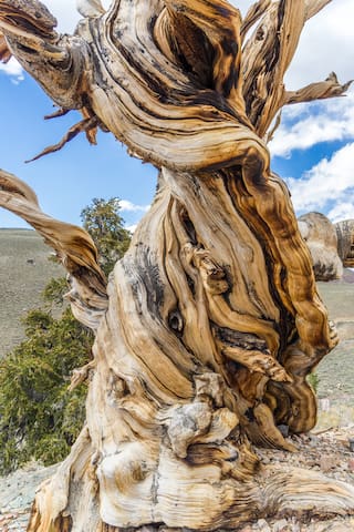
Ancient Bristlecone Pine Forest
White Mountain RoadThe trees of the Ancient Bristlecone Pine Forest in the White Mountains roughly an hour’s drive to the east of Bishop are the oldest recorded living thing on earth. A millennium older than the Giant Sequoia trees in the nearby Sierra, many are well over 2,000 years old and the “Methuselah” tree in Schulman Grove is dated at more than 4,773 years old. These trees were young and growing at the time stone axes were being used in Europe, the Great Pyramid of Khufu (Cheops) was being built, and cuneiform clay tablets were being used in northern Syria. Bristlecone pines (Pinus longaeva & aristata) grow in the White Mountains at elevations 9,000 to over 11,000 feet. The oldest trees grow on outcrops of dolomite, an alkaline calcareous, low nutrient soil. Only on the alkaline dolomite will you find pure, relatively dense stands of Bristlecone pine.
Rock climbing
A scenic high-desert climbing area situated above the town of Lone Pine with Mt Whitney and the Sierra crest as a backdrop. Close to 300 routes (trad and sport) on variable quality Josh-like rock. Stacks of easy to moderate well-protected climbs here as most development is quite recent. Free camping nearby with Bishop only an hour away. A fun laid-back area that's well worth a visit.
21 lokal ang nagrerekomenda
Alabama Hills
A scenic high-desert climbing area situated above the town of Lone Pine with Mt Whitney and the Sierra crest as a backdrop. Close to 300 routes (trad and sport) on variable quality Josh-like rock. Stacks of easy to moderate well-protected climbs here as most development is quite recent. Free camping nearby with Bishop only an hour away. A fun laid-back area that's well worth a visit.
The Buttermilks is a historical climbing area that is home to some of the worlds most famous rock climbs. It is located at the base of the Eastern Sierras near Bishop, CA. In this region there are 3 main bouldering areas: The Happies, The Sads, and The Buttermilks. The Buttermilks are massive granite boulders ranging up to 45' plus.
Buttermilk Boulders
Buttermilk RoadThe Buttermilks is a historical climbing area that is home to some of the worlds most famous rock climbs. It is located at the base of the Eastern Sierras near Bishop, CA. In this region there are 3 main bouldering areas: The Happies, The Sads, and The Buttermilks. The Buttermilks are massive granite boulders ranging up to 45' plus.
The Owens River Gorge is a deep, steep-sided canyon about 10 miles long located northwest of Bishop. The Owens River Gorge is California's most concentrated sport-climbing area. It is really a year-round crag, although summers can be a bit hot. There are many moderate sport climbs in the sub 5.10 range, but the best gorge climbs seem to be in the 5.10-5.11 range. The climbing is on volcanic tuff and features edges, pockets and cracks.
8 lokal ang nagrerekomenda
Owens River Gorge
The Owens River Gorge is a deep, steep-sided canyon about 10 miles long located northwest of Bishop. The Owens River Gorge is California's most concentrated sport-climbing area. It is really a year-round crag, although summers can be a bit hot. There are many moderate sport climbs in the sub 5.10 range, but the best gorge climbs seem to be in the 5.10-5.11 range. The climbing is on volcanic tuff and features edges, pockets and cracks.
Shopping
Everything you can possibly need to outfit yourself for the Sierras!
6 lokal ang nagrerekomenda
Elevation Sierra Adventure
150 S Main StEverything you can possibly need to outfit yourself for the Sierras!
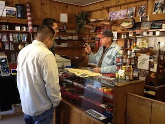
High Sierra Outfitters
130 S Main StGreat little sporting goods store with the best fishing advice in town!
This place has almost everything that you may have forgotten or need!
7 lokal ang nagrerekomenda
Gardner's True Value Hardware
104 S Main StThis place has almost everything that you may have forgotten or need!
Hiking
Glacier Lodge
100 Glacier Lodge RdAmazing Hike to this beautiful often secluded spot!
No permit needed to hike to Lone Pine Lake from Whitney Portal trailhead. After hiking 2.8 miles in (5.6 miles roundtrip), veer off to the left toward the lake. Please note, you will need a permit to go further up Mt. Whitney trail beyond this point.
Lone Pine Lake
Amazing Hike to this beautiful often secluded spot!
No permit needed to hike to Lone Pine Lake from Whitney Portal trailhead. After hiking 2.8 miles in (5.6 miles roundtrip), veer off to the left toward the lake. Please note, you will need a permit to go further up Mt. Whitney trail beyond this point.
GROCERY STORE
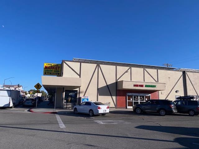
Lone pine market
119 S Main StVISITOR CENTER
Find all visitor and travel info, as well as, obtain permits for Mount Whitney and overnight backpacking in the high sierras.
10 lokal ang nagrerekomenda
Eastern Sierra Interagency Visitor Center
Find all visitor and travel info, as well as, obtain permits for Mount Whitney and overnight backpacking in the high sierras.